San Rafael needs a progressive after Nader Mansourian

First up: if you’re interested in becoming a new Director of Public Works for a small city, apply by the end of today. Downtown San Rafael, Image from  the Business Improvement District.

For years, San Rafael has been something of a mixed bag to Marin’s suburbanists. On the one hand, its downtown is the most transit-accessible places in the county. On the other, the network of one-way streets and pedestrian barriers – especially on Second and Third – have rendered large swathes of the city no-go zones for pedestrians.

With Nader Mansourian’s retirement as Director of Public Works in March, San Rafael has a chance to hire someone who makes moving people a greater priority. If I were a member of the city council, I would ask candidates the following questions:

1.       What do you believe the role of a city’s streets should be? The answer I’m looking for: for moving people, and for building the community's wealth. The answer I’m not looking for: to move vehicular traffic. The first answer indicates the candidate understands that traffic and street problems are more than just engineering issues around traffic flow. There are competing priorities for city streets.

The second answer indicates the opposite, that moving cars, regardless of the occupancy, is more important than pedestrian safety or encouraging more efficient use of the street network.

2.       What do you think of the NACTO standards? NACTO design guides have become one of the most important parts of building complete streets. They include scientifically evaluated standards for safe bike lanes of all types; for transit-only lanes; for arterial roads; and others.

Caltrans has endorsed NACTO's guides. Having a new director that embraces this shift is vital for the city.

3.       What do you feel the city can do to improve pedestrian safety? Roadways and pedestrian safety are more than simply a compact between people in cars and people on foot. Design can have a subtle and subconscious effect on driver and pedestrian behavior.

The most obvious results of Mansourian’s safety efforts are scores of Do Not Cross pedestrian barriers and the removal of the crosswalk at Third and Cijos. He largely didn't make use of the other, more subtle and effective tools in the toolbox.

San Rafael desperately needs a progressive in charge of its infrastructure, especially its streets. Mansourian was a highly effective engineer, but he was hidebound to outdated standards that run against the grain of modern best practices. San Rafael needs change. You should apply – applications are due at the end of the day.

New site, new store, same stuff

With the successful completion of my Kickstarter, I've bought a new domain, opened a map store, and started cross-posting. This blog will stay open but I'll stop updating the site after next week. If you subscribe by email, you'll need to sign up again. If you subscribe by RSS you'll want to update your link, too.

While I am excited about the new format and domain - this one is showing its age, and I really hate the ads at the bottom of some posts - what I'm really excited about is the Map Store. While I've threatened to print my maps before, this time I'm actually doing it. While I'm mostly focusing on subway-style maps of historical rail networks, I have a few maps for the Marinites, notably the Interurban.

My mapping queue is full for the next few months (DC/Baltimore, then Saint Louis, then Toronto), but I'm starting to think about what comes next. Check the maps you might want to buy for yourself or someone else:

[polldaddy poll=8849707]

All of these, except for Highway 101, are for the 1921 versions. The Highway 101 strip map will include all service that runs on the freeway from Cloverdale to San Francisco. It would likely be a fold-out pocket map, a nice addition to your GGT transit guide.

It's been nice getting to know everyone on Wordpress, but Squarespace gives me much better commercial integration. See you over there.

Sausalito in a backwards fight against ferries

For years, Sausalito had struggled with its success. Tourists on rental bikes flood the town every summer, creating a logistical and transportation nightmare for the small city. Recently, attempts by the city council to cope with the challenge have been less about addressing the issue and more about resentment against tourists, cyclists, and the ferries they rely upon. The City Council looks set to vote its opposition to an expanded Golden Gate Ferry facility and has already expressed opposition to a National Park Service ferry to Fort Baker.

Background

Sausalito is part of the natural loop of bike-riding tourists to San Francisco: rent a bike, cross the Golden Gate Bridge, head down to Sausalito, hang out, then take a ferry back. Simple, easy. But downtown Sausalito is a tightly constrained place. Bridgeway, the only road running the full length through downtown, doesn't have the facilities to handle its bike traffic, and so it spills over onto sidewalks, rankling locals. According to Marinscope, some ferries have to leave for San Francisco half full because of the sheer number of people with bikes.

As far back as 2009 at least, the more colorful described these bike-riding tourists as "locusts." In 2015, conservative councilmember Linda Pfeifer proposed limiting the number of people on bikes from entering the city.

Sausalito isn't the only place with tourist problems. Tam Valley has been groaning under the weight of tourist traffic heading to Muir Woods along Shoreline Highway. Sharon Rushton, a political ally of Councilmember Pfeifer, has been fighting the National Park Service's proposals around the national monument for years, whether it has meant fighting shuttles, parking, or parking management.

Back to Sausalito

To help address the number of people taking the Sausalito Ferry with bicycles, GGBHTD has proposed expanding its Sausalito terminal.

The proposed ferry terminal redesign from the air.

According to planning documents (large PDF) the new terminal would allow a fully-loaded Spaulding ferry, which can accommodate up to 750 passengers with up to 100 bikes, to unload in 3 minutes and load in 6. This is a dramatic improvement over existing conditions, where ferries are reported to sometimes leave half-full.

As well, the new design would allow passengers with bikes to load simultaneously and separately from those without bikes, reducing some of the friction that causes delays in off-loading at San Francisco.

But the proposal has raised hackles with the council. Those opposed to the redesign aren't happy with the final pier's distance from shore and the amount of water covered. They'd like GGBHTD to begin regular dredging of the area so ferries could come closer to shore.

The existing ferry terminal.

The proposed ferry terminal, as seen from the nearby Yacht Club.

To my eyes, the new design looks only slightly more intrusive than the old; it's unclear to me why adding an additional and ongoing expense of dredging would be necessary. Perhaps a commenter could enlighten me as to the downside of the new design's size.

This is not the only ferry project that may happen around Sausalito.

A National Park ferry at Fort Baker?

Two miles south, the National Park Service (NPS) is interested in building a new ferry terminal at Fort Baker. While details are sketchy, the NPS has said the ferry would be operated by the same company that currently operates Alcatraz service. According to Marinscope, the terminal would only be used for "special events" and would not include a parking lot.

According to Brian Aviles, planner for the NPS:

The intent is to complement the programs at Fort Baker and perhaps allow people to visit Fort Baker without having to drive. We felt it prudent to investigate installing a gangway and float. It would function to link the main Alcatraz embarkation point to Fort Baker. (quoted by Marinscope)

According to the San Francisco Chronicle, this is part of a larger project to add ferry service to water-adjacent NPS sites around the Bay, including Rosie the Riveter National Historic Park in Richmond. It would allow NPS to focus tourist traffic towards ferry service rather than the current collection of ferries, shuttles, and parking lots.

While not part of the project's scope, Sausalito City Manager Adam Politzer finds the idea of NPS shuttles on Sausalito streets frightening:

Having a ferry terminal at Fort Baker, even just for special events, would create traffic on both Alexander Avenue and Highway 101, exacerbating an already intolerable traffic situation... The increased traffic would place strains of vehicle movement and parking. Adding shuttle buses to the mix would also increase congestion on busy Sausalito streets.

Councilmember Pfeifer adds:

It is pretty obvious what the strategic goal is... I can see over time they will be directing the overflow [from Alcatraz] to Fort Baker and shifting those folks to downtown Sausalito.

The concerns expressed by Politzer and Pfeifer echo Rushton's complaints about the NPS and Muir Woods. Through her organization, Sustainable TamAlmonte, Rushton and others have advocated to limit the absolute number of visitors to Muir Woods per year and has opposed efforts to expand local shuttle service, saying that such ideas amount to commercialization of the monument.

Yet this ferry concept seems to fit perfectly with Sustainable TamAlmonte's proposed alternative, which is point-of-origin shuttle service. In a 2013 letter to the Board of Supervisors, Rushton writes:

If an Independent Scientific Carrying Capacity Study on visitor load for Muir Woods and related parking & traffic proves the need for a more robust shuttle system, establish a Muir Woods Shuttle System (using small shuttle buses) that picks up and drops off Muir Woods’ visitors at regional points of origin (E.g. San Francisco, East Bay, and North Bay) and NOT within the Tamalpais Area Community Plan area.

Without a parking lot, the Fort Baker ferry terminal could only be a shuttle for tourists from San Francisco and never add to traffic congestion on Sausalito streets. Even under the most intense use of a ferry - the implementation of shuttle service - would likely only add 2 vehicles per hour per direction to Bridgeway, hardly a tipping point. And, by encouraging tourists to forego car rentals entirely, it might actually cut down on the amount of vehicular traffic within Sausalito.

Sausalito’s city council is standing in opposition to transit from two providers that could be vital to reducing congestion in their city and Southern Marin at large. The professed reasons to oppose either project – the scale of the GGBHTD proposal, traffic at the parking-free NPS proposal – don’t hold up to scrutiny.

Thankfully, neither proposal is likely to be seriously affected. GGBHTD may modify their ferry terminal design, but the project will go ahead when the council majority – with which Pfeifer generally does not vote – is satisfied with any changes. And the EIR commissioned by Sausalito on the NPS proposal may shed valuable light on the terminal’s impact and reiterate the baselessness of traffic concerns.

Sausalito and Southern Marin does have a serious tourist traffic problem, but opposing ferries and shuttles won't help mitigate the problem.

Ch-ch-ch-changes

Over the past month, I’ve been working hard on my historic railroad mapping project, which is doing well over on Kickstarter. For sale are also 12x12 to 24x24 prints of the Northwestern Interurban map. If there’s enough demand, when the store opens up in May I’ll also include prints of the Highway 101 Strip Map and, if the project ever finishes, the North Bay Bus Map. That’s not all I’ve been up to. I married a beautiful linguist, been accepted to graduate school, scrambled to find the money to fund said graduate school, and become involved to some degree in developing world urban policies. (Kinshasa and the Democratic Republic of Congo is an especially fascinating story.)

Of course, this has used up a great deal of time, and so I haven’t been able to update this blog as much as I ought to have. There is no shortage of issues to discuss, from the gorgeous new renderings of Whistlestop’s development proposal to Sausalito’s battle with transit, ferries, and tourists.

On top of all that, there is research out about the multiplier effects of transit-oriented design that I’ve been sitting on since February, a proposal for an on-street bike path from San Rafael to The Hub I’ve been sitting on since last year, and more. There’s so much to cover and so little time.

Marin County is fascinating not simply because of its place as my family home but also because its challenges are the challenges of suburbs around the country writ small. We avoided many of the problems plaguing many of America’s new suburbs but are reticent to tackle our own.

Next month, The Greater Marin will reopen on a new site, theGreaterMarin.org, advertisement-free and integrated with a store to purchase prints of the various mapping projects (the good ones) I’ve done over the years.

TGM has been on an unplanned hiatus, but I’m not going anywhere.

Thoughts of a progressive urbanist

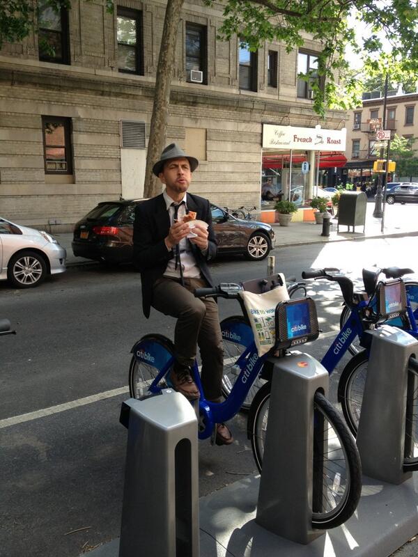
The author on a Citibike. When Citibike debuted in NYC in May of this year I happened to be visiting while on tour with a choir I sing in. As a pro-bicycle, three-year car-free San Franciscan I was giddy about the Citibike launch, I even posed for a photo on one out of sheer exuberance on the day before they were made available.

The Citibike launch is now history and the prediction of the streets of NYC running with the blood of neophyte bikers turned out to be overblown but one impression from that weekend has stayed with me: two of my friends there, both life-long New Yorkers, one progressive, one conservative, agreed: they hated Citibike.

The conservative friend parroted the Murdoch papers’ complaints: it will be a bloodbath, old ladies will be knocked over willy-nilly, cyclists are lawless, non-taxpaying “hipsters” and clueless liberals heedless to the safety of themselves and others. The progressive friend, equally scornful, rattled off the progressive objections; Citibank is the Great Satan; why are we plastering our city with ads to these robber barons? Why is this program confined to wealthy white neighborhoods?

These positions illustrate the extreme political poles of the urbanism debate Jason Henderson so brilliantly frames in his great book, Street Fight: The Politics of Mobility in San Francisco. The middle position or “third way “ not depicted in my representation of the Citibike debate is the neo-liberal position (pro-Citibike), with which I think most self-described urbanists would identify. David Edmondson [ed. - founder of this blog] is an example.

It’s doubtful conservatives in the US can be won over to some of the core tenants of urbanism. Automobility is a defining characteristic of American conservatism. Fears of Agenda 21 and “one world government,” hostility towards the nanny state, and climate change skepticism make urbanism anathema to even mainstream conservatives.

Progressives however, can and should be persuaded to support urbanism’s goals. While progressives and urbanists often clash, recently and most visibly in the Bay Area over the question of gentrification (the Google Bus phenomenon) and labor issues (the BART strike), I believe these two groups have much more in common than they have in conflict.

Progressives and urbanists are united over the urgency of climate change and environmental degradation. In general, progressives and urbanists can agree on the need for revitalized cities as a solution, but they often part company with how to get there.

Neo-liberal urbanists offer market solutions to these problems, and view “livability” as an urban quality best viewed as a commodity. Progressives stress state solutions and social justice as integral to the project of urbanism.

Many progressives perceive “livability” as synonymous with gentrification. These progressives see parklets, bike lanes, bike share and events like Sunday Streets in San Francisco as part of an insidious march towards a city of privilege, for the rich only. I have even encountered progressives who defend access to cheap parking and automobility for the poor and working classes as a social justice issue.

My experience with these issues comes from my perspective as a resident of San Francisco. As a progressive sympathetic to urbanist goals, my desire is to appeal to both sides in this debate and harness the energy of both groups to drive a move towards dense, low-carbon, livable cities. If I could talk to both sides in this debate in this moment I would say this:

To urbanists

Stop focusing your support on high-end development and be more sensitive to the problems caused by gentrification. Gentrification reduces economic and class diversity and decreases a city’s cultural capital by displacing the creative class that makes the city attractive to begin with.

As well, it displaces the poor and working class folks who are the perfect constituency for public transit. These people end up moving to the outer urban core and contribute to increased automobility as a result. Likewise, high-income folks are generally wedded to automobility, their injection into the urban fabric in parking intensive developments increases automobility in the city.

The optics of luxury developments, like San Francisco’s 8 Washington, further drive a wedge between progressives and urbanists.

Urbanists are part of a professional class (architects, planners) who are by their nature and training data-driven thinkers. This fact blinds urbanists to the importance and validity of emotional responses to the use of urban space. Nothing could be more emotional in some ways than an individual’s identification with the place they live.

Urbanists should be wary of their own predilection to dismiss and belittle emotional reactions to development and gentrification particularly when they enter the political realm (as through Proposition B, which would approve 8 Washington) to further their goals.

To progressives

Livability is not gentrification, and anti-growth is not anti-gentrification.

Improvements to livability in the public space benefit all classes. Stop singling out parklets and bike lanes as evil, and learn to support increased density near transit. Dense development will increase housing stock and drive down displacement, reducing dependence on automobility among the poor and working class by providing a more robust (and yes, partially higher-end) constituency for public transit.

Acknowledge that dense development is inevitable, and that some of it will be luxury. As Edmondson has written before, luxury developments can and do take pressure off the housing market by shifting demand from existing “low-end” housing stock, thereby easing the market and slowing displacement.

Opposition to automobility should be a progressive social justice issue. The primacy of cars in the city places undue strain on poor and working class folks. It clogs our streets and slows public transit. A bifurcated, inequitable system, where the poor depend on transit slowed and made unreliable by the rich driving around them, is the result. The costs of car ownership – insurance, maintenance, and parking fines – are all borne disproportionately by working folks. Freeing them from automobility will engender increased social mobility.

Poor and working class neighborhoods near freeways and high-traffic city streets disproportionately suffer the worst health effects of automobility’s pollution. High rates of cancer and respiratory problems are the result. Globally, the effects of climate change brought about largely by car- and carbon-intensive cities will hit the world’s poor hardest.

Mostly, let’s all break free of the zero-sum tenor of internet discourse. Stop yelling past one another and listen. If we agree to do that, progressives and urbanists working together can achieve the common goal of sustainable cities. The time to make history is now. Let’s be the change we want to see.

Cross-posted with Vibrant Bay Area.

A reality check for Randy Warren’s climate change plan

A candidate for San Rafael City Council has a bold plan to cut transportation CO2 emissions: subsidize electric cars. While at surface it sounds reasonable enough, the plan would be expensive for little gain. Take a look at candidate Randy Warren’s platform and you’ll find, under the climate change header, a description for Operation New Leaf.

For all the theories about what we can do to reduce greenhouse gasses from cars and light trucks, the reality is that the plans are speculation and hope.  Let’s aim instead for guaranteed results.  I propose Operation New Leaf, a plan to provide incentives for our out-of-county workforce to purchase zero emission cars for their commute to San Rafael. This plan targets workers who have held a San Rafael job for at least one year and live at least 20 miles away. The city would negotiate special rates with San Rafael car dealers, from whom the cars would have to be purchased or leased.  Participating workers would have to make a good faith pledge to do their workday shopping in San Rafael, so we improve our local economy and recover some operating costs via related sales tax.  We would target up to a 50% subsidy to the workers, with proper safeguards.  We then need to line up sponsors, whether from MTC or the private sector (including the car manufacturers themselves as a pilot program).  This is a complex proposal that requires a city study group, and I will encourage such study take place.  But until our legislature has the guts to set a date for banning the registration of new gas-powered cars, Operation New Leaf would produce instant and certain results in reducing greenhouse gasses.

The Census doesn’t estimate the source of in-commuting jobs by city, but we can estimate. There are roughly 43,000 jobs in the city. Of Marin jobs, a quarter are held by workers in counties at least 20 miles away from San Rafael (i.e., all but San Francisco and Contra Costa). Proportionally, that means about 7,760 San Rafael workers live about 20 miles away or more. With that in mind, I estimate the cost of Operation New Leaf at around $97 million, not including the cost to move an additional 1,000 cars to the city’s job centers and store them once they get there.

Would MTC help? Likely not, given their pursuit of multi-modal solutions to transportation problems. Would Nissan help so they could promote their electric Leaf? Probably not enough to make the project affordable. Would a change in drivers’ shopping habits offset the cost? Again, probably not enough to make it affordable to the city. Leasing the vehicles instead of buying them outright might put the cost into a more-affordable area around $10 million per year, but that’s still far more than San Rafael could carry.

Equally as unaffordable are the consequences.

The cost to congestion would be enormous, given that this would be like closing a traffic lane on Highway 101. And the cost to our built environment would be high, too. San Rafael would suddenly need to find parking for at least another 1,000 cars per day [see update below], not to mention charging stations for not just these 1,000 vehicles but the 10,000 others bought by people who already drive to the city.

This might be net-negative in greenhouse gas emissions, provided increased congestion doesn’t make the situation worse, but it wouldn’t be a panacea. Electric cars in California emit the equivalent CO2 of a 70mpg gasoline car. BART, in contrast, emits the equivalent of around 940mpg. It would also put those currently taking transit to work into harm’s way (driving kills 35,000 people per year), and fight downtown San Rafael’s efforts to expand its walkable downtown east of Highway 101.

To reduce transportation greenhouse gas emissions, San Rafael ought to try to segment the travel market for trips under 2 miles, where most car trips are made. Some of those really are best done by car, but others are best done on foot or bike. How we build our roads and grow San Rafael should allow each mode to function best in balance with the others.

For walking, that means maintaining sidewalks and slowing down the perceived speed of cars, which can drive away foot traffic. For biking, it means building quality bike infrastructure that is safe for anyone age 8 to 80. For driving, it means encouraging people who don’t need to drive to leave the car at home and out of the way of other drivers. Even if a few percent of trips shift from car to another mode, that's often enough to unlock traffic flow.

Or, if San Rafael really wants to spend millions of its own dollars on transportation, it could build a comprehensive Class I bicycle lane network for the whole city and Ross Valley with money to spare. It could provide free transit passes to in-commuters, cleaning up traffic while also cleaning the air. It could buy 48 hydrogen fuel-cell buses for Golden Gate Transit, or (for less money) retrofit Marin’s entire bus fleet to run on compressed natural gas.

Operation New Leaf doesn’t solve any problems faced by San Rafael; quite the opposite, it spends millions to exacerbate its existing problems. And, far from providing "guaranteed results," it could add to congestion-related CO2 emissions, possibly even enough to offset the gains.

Electric cars are touted as the solution to our transportation emissions, but it ignores the other costs of pushing car-only infrastructure: parking, traffic, public safety, and car maintenance. The way to reduce Marin's greenhouse gas emissions is to diversify away from an automobile monoculture, not to deepen it. And, in the meantime, we'd solve our transportation problems, too.

UPDATE AND CLARIFICATION: Some questions have arisen as to why more cars would be on the road under this scheme. Roughly 11 percent of Marin's in-commuters take transit to work, and it's reasonable to suspect slightly more take transit to San Rafael given the presence of the transit center. By subsidizing car ownership, it's reasonable to assume a good chunk of them would choose to drive instead and add more vehicles to the city and Highway 101.

Where do the PDA funds go now?

The future downtown station area will need some work. Image from City of San Rafael. Now that the Civic Center Priority Development Area (PDA) has been rescinded, TAM is left with a bucket of PDA-designated cash and even fewer places put it. While Mayor Gary Phillips says downtown San Rafael’s PDA is a logical place to put it, none of the proposed projects in the area are at a stage where they need funding.

Part of the delay is due to San Rafael Public Works (DPW) Director Nader Mansourian’s reported insistence that any road alterations wait until after SMART starts service in 2016. As a result, anything that might disrupt a road’s or intersection’s capacity, or level of service (LOS) will have to wait until the needed capacity is known. That includes bike lanes, traffic lights, crosswalks, bus lanes, etc.

PDA funds must be dedicated to improving the transportation infrastructure within a PDA. While they can target projects outside of a PDA, the project must have a direct positive effect on transportation service within the PDA.

It’s up to the Council and staff to get a slate of needed improvements to the area, from the small to the large. Some possible proposals:

Study which projects in the Downtown Station Area Plan would and would not impact traffic. This is probably the most basic study that would need to be conducted, given that it will be three years before SMART runs and likely another year beyond that before traffic patterns start to emerge. This would give a slate of small projects that could be priced, studied, and built before the train.

Link traffic lights to the rail crossings, done in concert with SMART’s work on the rail crossings themselves. When trains start moving through downtown, they will need to coordinate with traffic flow By linking traffic lights to the crossings, San Rafael could prepare for the trains’ arrival today. The linkage will need to happen on Day One of train operations, and so cannot wait for traffic studies to even begin.

While they’re at it, link traffic lights to bus service. Buses currently crawl through downtown San Rafael, especially northbound trunk service like routes 71 and 101. By allowing traffic lights to sense approaching buses and turn green, a system called signal priority, San Rafael could improve speeds for all bus travelers and improve transit access to and through the downtown station area. While DPW will no doubt want a traffic study to find out precisely how the system should work after SMART, the study will only show how to tweak the system once SMART runs. Benefits could flow long before then.

Fix the Andersen Drive/SMART crossing. One of the principal barriers to getting SMART down to Larkspur is not the station or track but the at-grade intersection of SMART tracks and Andersen Drive. The angle of approach for the train is too shallow for state regulators and so will need to be fixed before the train can proceed south to the ferry terminal. Given that the problem was caused by San Rafael when they extended Andersen, it’s on San Rafael’s head to fix the $6 million problem.

Begin a comparison study of how people move through and shop in downtown. How do shoppers get to downtown? How many people move through downtown? This will give San Rafael planners a snapshot of how SMART and the Station Area Plan changes San Rafael and how to target improvements in the future.

The other pressing projects, even under-freeway parking garages (proposed by the Station Area Plan), will change traffic flow and so won’t pass Mansourian’s muster without a Council mandate. However, staff should draw up a decision tree and timetable for implementation of bike, parking, transit, and other traffic-impacting roadway improvements before SMART begins,

What else would be a good fit for TAM’s PDA-dedicated funds?

Note: I reached out to TAM to determine which of these projects are fundable with PDA money and which are not, but staff have been in a crunch time and haven't been able to answer. I'll post an update when they reply.

Regional democracy wouldn't pan out for slow-growth

Unelected bureaucrats want to impose their will upon us, cry critics of Plan Bay Area. Nobody chose their town’s representative to the Association of Bay Area Governments (ABAG), after all. We elected them to city councils, not the ABAG General Assembly or Executive Committee. Plan Bay Area, passed by these unelected appointees, then, is an affront to democracy and the fair people of the Bay Area. This is, roughly, also the central thrust of a Marin Voice piece by Susan Kirsch, head of Sustainable TamAlmonte spokeswoman for Citizen Marin and Friends of Mill Valley.

So why not elect them?

Intriguingly, there was a plan about two years ago to create just such a body. SB 1149, by far-East Bay senator Mark DeSaulnier, would have created the Bay Area Regional Commission, or BARC. The bill, which died in committee last year, would have had 15 members, each elected from a district of equal population. BARC would have rolled the powers of ABAG, the Metropolitan Transportation Commission (MTC), the Bay Area Air Quality Management District (BAAQMD), and the San Francisco Bay Conservation and Development Commission (BCDC) into a single agency.

A hypothetical BARC would realize significant savings by eliminating redundancies, have the legitimacy of being controlled by an elected body, and improve interagency coordination. Rather than passing Plan Bay Area through a body of officials elected to local government then appointed to regional government, it would have been passed by a body of officials elected to regional government full-time.

In case you’re wondering, a one-county-one-vote BARC would be illegal if the county representatives were elected. The Supreme Court ruled in 1989 that electoral districts of special areas, like a BARC, must be of roughly equal population. The only way for us to get one-county-one-vote is through appointed boards, which how ABAG currently does things.

But one gets the feeling Kirsch and other activists in line with her would not be so enthusiastic about it. Rather than emphasize local control, a regional elected body would put the emphasis on the region instead. On top of that, Marin wouldn’t even get their own elected representative, given its small population. It would have to share one with Sonoma.

The push by Kirsch and others is really for local control and local democracy, not a regional democracy. If Plan Bay Area had been passed by a hypothetical BARC, I can only imagine they’d say they we’ve been outvoted by the rest of the region. Had it been put to a plebiscite, they’d likely say the same thing. After all, for residents of Kirsch’s tiny Tam Valley it is their world. Why would they cede control to people in Gilroy and Fairfield who have probably never even heard of Tam Valley?

While I support BARC in theory, given the regionalist perspectives of the other counties, I fear that it would only further embitter isolationist Marin. And, while I support the idea of putting Plan Bay Area to a regional plebiscite in theory, I fear the losing side would not embrace the result as legitimate, whether it passed or not. On top of that, it wouldn’t really address Kirsch’s underlying concern: that Plan Bay Area is not good policy for Marin or anywhere.

The way forward in regional governance is one I’ve said before: for Marin to create its own subregion. It would be able to have direct control over its regional housing needs allocation (RHNA), focusing development into the towns or areas most willing and able to take it. It would take control out of the hands of the region and into the hands of Marin’s governments.

Putting more democracy into the system won’t help Marin find self-determination, nor will it help the region address the concerns Kirsch and others raise. Bringing affordable housing decisions to Marin, however, will at least get that part back into the hands of our own elected officials.

Mid-week links: Marin Transit

Marin County The latest Marin Transit board meeting was one full of change and surprise. Amid increasing ridership (though it fell in June), MT posted a $1.5 million surplus, which will go into a rainy day fund. To keep ridership on the up and up, the agency hired a new communications and advertising consultant, who will manage MT's branding, website, social media, and communications strategy. IJ reporter Nels Johnson, however, seemed to think the $300,000 consultant was taking the agency "for a spin." And, in the name of efficiency, the MT board cut Route 222, which got less than 3 riders per hour in June. Elsewhere:

  • There was so much public comment about Marin's new housing element that the Board of Supervisors had to postpone its debate until next week. (Patch) On a side note, whoever's idea it was to bring in a saxophonist to lead the potentially rancorous crowd in singing, "There's still a lot of love in Marin!" is brilliant. (IJ)
  • The Civic Center Drive upgrades look fabulous, but now that they aren't in a PDA TAM may need to rescind its funding. (Patch)
  • A driver hit a bicyclist in Fairfax yesterday by turning left through a bike lane, sending the bicyclist to the hospital with a broken collar bone. Though the circumstances seem like they warranted an investigation or a failure-to-yield citation, the driver was not cited by police. (IJ)
  • The costs of demand-responsive bus service, promoted by Bob Silvestri as the ideal transit, make it an ineffective replacement for traditional bus service. (Listen Marin)
  • The lack of BART in Marin is apparently because we're classist and racist and always have been. (The Grid) Except, y'know, that's not at all why we don't have BART.
  • TAM should take on all the causes of congestion on Highway 101, not just cars, according to Corte Madera Mayor Diane Furst. She sat on a working group to draft an alternative plan to flyovers on the freeway. (Marin Voice)
  • The Golden Gate Bridge will close for a full weekend next year for the installation of a new movable barrier. This will be the first time in the bridge's history it will be closed for more than a few hours. (IJ)
  • Parking minimums can severely constrain construction, either driving up rents in the building or preventing new construction altogether and contributing to a housing shortage. Affordable housing advocates take note. (Sightline)

Politics

  • San Rafael council candidate Randy Warren hits rival Maribeth Bushey-Lang hard, saying her need to recuse herself over issues like SMART make her unfit for service. (IJ)
  • The move to recall Supervisor Susan Adams failed to attract enough signatures, and Save Marinwood is not happy. Interestingly, no signatures were submitted to the county, so we'll never know how far short the recall came. (IJ, Save Marinwood)
  • Paul Mamalakis examines the race for Novato City Council. (Advance)

Story update: San Rafael rescinds Civic Center PDA

As everyone no doubt heard, the San Rafael City Council voted last night to rescind the North San Rafael Priority Development Area (PDA) on a 3-2 vote. Mayor Gary Phillips and councilmembers Kate Colin and Damon Connolly voted to rescind. Councilmembers Andrew McCullough and Barbara Heller voted to keep the PDA. Slow-growth activists decried the PDA as a high-density housing plan that would burden the city’s schools and water supply while destroying the drivable suburban character in the neighborhood. Urbanists and environmentalists said the PDA carries no strings whatsoever, that the housing guidelines were nonbinding suggestions, and was a way to fund improvements for the San Rafael that exists today.

At a county level, eyes now turn to the Strawberry PDA, which has come under attack by critics for much the same reasons other PDAs have. The argument will likely take much the same shape as it did last night, though it remains to be seen whether Supervisor Kate Sears will propose to remove the PDA or not. Given that she has not come under the same withering criticism Supervisor Susan Adams did over the Marinwood PDA, it may remain intact for the foreseeable future.

At a city level, the downtown San Rafael PDA also remains intact. Mayor Phillips and others who opposed the Civic Center PDA have said the housing suggestions make much more sense downtown and that regional money would do more good in that area anyway. Still, slow-growth advocates, convinced that the PDAs constitute a mandate for housing, are likely to attack this PDA, too. Council candidate Randy Warren, for one, has argued this designation should be rescinded, too.

A future post will look at how San Rafael and TAM could make lemonade out of the situation and the barriers to getting PDA-designated funds from TAM’s account into projects on the ground.


Politics threatens good policy in North San Rafael

There seems to be a majority forming on the San Rafael City Council to rescind the Civic Center Planned Development Area (PDA). At last week’s special session on the subject, three of the city’s five councilmembers (Mayor Gary Phillips, Councilmember Damon Connolly, and Councilmember Kate Colin) expressed opposition to the PDA. While each expressed their own reasons for opposition, most swirled around the idea that, if we keep the PDA, San Rafael will be obligated to build massive quantities of affordable housing in an area that cannot support it. Fortunately, this is simply untrue.

What would the PDA actually do?

PDAs are an investment vehicle originally created by MTC. Cities tell regional agencies where they plan to focus population and job growth, and the region earmarks regional transportation money for those areas. In Marin, MTC requires that half of those regional transportation funds go the county’s PDAs. The other half can go to transportation projects anywhere in the county. While there is some talk in Sacramento to channel climate change transportation funds exclusively to PDAs, that proposal has not been finalized.

To help guide local planners, each PDA has a different “place-type” designation, which provides nonbinding guidelines about residential density and the quality of transit service. North San Rafael is a Transit Town Center, which MTC recommends should have or plan for between 3,000 and 7,500 housing units.

But, as a nonbinding recommendation, there is no obligation on San Rafael to actually zone for or build the recommended number of housing units. Rather, the recommendation is there to help San Rafael planners craft a local plan, which was done with the Station Area and General Plans.

There is concern about CEQA streamlining for affordable housing projects within PDAs, but the state doesn’t obligate the city or county to loosen its own environmental review processes. If the city decides a project shouldn’t receive CEQA streamlining, it won’t. This, as the only non-funding legal aspect of a PDA, is still well within the control of the city.

So what is the fear?

Anti-development (“slow growth”) activists in North San Rafael are concerned that the PDA creates an obligation to the city to zone for thousands more housing units than it could actually support, clogging streets, stuffing classrooms, and putting people in harm’s way along busy, high-speed arterial streets. We don’t have the water, don’t have the class space, don’t have the road space, and don’t have the tax revenue to take in so many new people.

But the PDA doesn’t obligate a thing. Mayor Phillips Councilmember Colin had another answer to that. They said it would be dishonest to use a place-type with a higher housing guideline than could realistically be put into the area without adverse impacts to existing residents.

As a nonbinding guideline, then, it would make sense for the city to simply downgrade the PDA to a level that falls in line with the existing level of housing development.  In fact, this is precisely what Councilmember Andrew McCullough proposed, and is one of the optional resolutions for Monday’s council meeting.

Why would we want a PDA?

Because North San Rafael has over $25 million in transportation needs, and the city is considering raising a sales tax because it can’t fund its existing obligations. It needs some extra funds if it wants to improve the neighborhood’s roads.

In fact, one project is very likely to be funded with PDA money: the proposed improvements to the Civic Center campus. Without the PDA, the $3 million project will be ineligible for regional money, and TAM will be forced to shift those funds to another PDA in the county.

But beyond that, a theme of those who spoke in favor of the PDA was that the neighborhood was unfriendly and unsafe for people walking or biking. Given the relative lack of bike lanes, bad connections to regional and local transit, and missing or crumbling sidewalks, it’s a wonder people haven’t been killed. Drivers, too, need to battle with congestion. They have been patiently waiting for a new freeway interchange for years.

All this could be funded by regional transportation dollars, or would need to compete with projects in the rest of the county. The PDA, as a funding tool, would put these projects on a fast track for approval and funding. Removing the PDA would likely cut the neighborhood off for years.

Politics, not policy, is at work

So the PDA doesn’t obligate any development, doesn’t obligate any zoning, and provides a way to make North San Rafael safer for kids to walk to school and commuters to get to the bus. If the PDA does start to obligate the city to do things it does not want to do, or even if it’s threatened, the city could rescind the PDA with no problem at that point. So why is the council voting on Monday? Alas, it’s about politics, not policy.

It’s an election year. Councilmember Damon Connolly is running against Susan Adams and Councilmember Kate Colin is fighting for her seat against slow-growth candidate Randy Warren. The county’s slow growth movement has fought against PDAs as a proxy for their fight against Plan Bay Area.

By setting themselves up against the North San Rafael PDA, Connolly and Colin are betting they can inoculate themselves against attacks from that camp. At first glance, that seems like a safe bet. Polling from One Bay Area shows that those with anti-development sentiment are more passionate about the issue and are more likely to vote than their counterparts.

Yet they are forgetting that Marinites want choices in how they travel and how they live. It’s not as easy a sell on the campaign trail, but it would be the way for Mayor Phillips and Councilmember Colin to knock the wind out of the slow-growth lobby.

The best compromise is to vote for downgrading the PDA. While it won’t satisfy those who lead the movement, it will show that the council is concerned about density and height while balancing it against transportation improvements North San Rafael desperately needs.

A fragmented BABS is bad for the region

UPDATE: Bay Area Bike Share has confirmed that you can, indeed, dock bikes between any participating city. It's unclear why Peter Colijn was unable to dock his bike. UPDATED UPDATE: Well, the BABS website has been updated saying that San Francisco and the rest of the system are separate, in that you can't bike from SF to other parts of the system, nor vice versa. But if you wanted to, say, bike from San Jose to Mountain View, you could dock your bike.

It took less than a week for an intrepid bicyclist to decide it was time to ride a Bay Area Bike Share (BABS) bike from San Francisco to Mountain View. Given our region’s strong corps of Bicyclists, it was only a matter of time, really.

But when the bicyclist, Peter Colijn, got to Mountain View, he couldn’t dock his bike. It seems BABS has set up not just different clusters of stations, but different systems altogether, where bikes from different clusters won’t dock at another cluster’s stations. This does not bode well for BABS.

As BABS expands, the clusters will get close enough that users could easily ride from one to the other.  By splitting what purports to be a unified system into chunks, riders won’t be able to do what it clearly seems like they should be able to do: ride across city lines. It will make rebalancing more difficult in the future, too, as the bikes won’t be interchangeable with one another.

There is a simpler reason why this is a bad idea: people will do dumb and unusual things with BABS, and splitting the system up will exacerbate the consequences.

As a long-time observer of Washington, DC’s Capital Bikeshare (CaBi) program, which uses the same technology as BABS, I can say that I’ve seen just about everything. People take out their bikes for the day, lock them to bike racks, take them on the Metro, bring them into the office, and all sorts of other things you definitely shouldn’t do with a bike share bike. (CaBi has assured me and others in DC that they are very willing to cut overage fees, especially for bikes out more than 24 hours, when people didn’t understand the system.)

The same thing will happen in the San Francisco Bay Area. People will take the bikes on Caltrain, do long-distance group rides, and other things that will cost them a great deal in overage charges, often unwittingly. If users can’t dock their bikes in different cities, they’ll get double pain. Not only will they get hit with overage fees, but they’ll be stranded with the wrong bike in the wrong area.

I suspect BABS separated the systems to make rebalancing easier. There’s no way for a cluster’s bikes to migrate away from it, so each city keeps its “fair share” of bikes. But this doesn’t account for users’ creativity or lack of knowledge about the system.

BABS should give people allowance to do things outside how they want users to ideally use their system. Let the hardcore cyclists do their marathon runs and brag about them on Strava – it’s free publicity! Let the inexperienced and the tourist take the bikes on Caltrain or ride them from San Jose to Mountain View. It would be easier to pick up bikes that people ride to the “wrong” place on BABS’ own time than to force innocent users to travel all the way back to wherever they came from. It would certainly beat the bad the publicity of an angry customer who, quite understandably, thought that all BABS stations were the same.

I have an email out to BAAQMD, BABS’ manager, to find out which clusters are interoperable and which aren’t. A comment on Cyclicious says Palo Alto and Mountain View bikes are interoperable, but I don't know anything beyond that. See update above.

Bike share for the ferry terminals

Last week, Bay area Bike Share (BABS) launched to some fanfare. Caltrain commuters and residents in a few neighborhoods along the Peninsula and in San Francisco can now bike to or from transit, making the first and last mile a bit easier. Calls for a broader bike share program to serve the East Bay, more Peninsula neighborhoods, and the whole of San Francisco have risen ever since the limited scope of the project was announced.

Advocates should add Vallejo and Larkspur-San Rafael to their list. As the outer ends of the Bay Area’s ferry service, they desperately need some way to bridge that last mile. Bike share is how to do it.

Why ferries?

A chronic problem with ferry service in the Bay Area is the lack of bi-directional demand. Though many San Franciscans work in Marin and Solano, it’s tough to get reliable transit service to their employment centers. Golden Gate Transit buses depart hourly heading north, even in the morning commute hour. SolTrans buses don’t even offer reverse-commute service.

While there is ferry service to Larkspur and Vallejo, there aren’t many jobs within walking distance of the terminals. Driving, then, is often the only viable mode, closing off those jobs available from car-less San Franciscans.

BABS stations could change that.

In Vallejo, the principal would be similar to the Caltrain satellite systems, like in Palo Alto. Scatter a few stations around the downtown, with a large one at the ferry terminal, and you’ve created is an easy way for commuters to head to or from the ferry terminal without the need to drive or to bring their own bike.

In Larkspur, the ferry terminal’s distance from downtown San Rafael, the county’s employment hub, means a more creative solution is needed.

A large BABS station at the ferry terminal, another in Greenbrae, and a few scattered around downtown San Rafael would allow reverse-commuters to use it as their last mile and draw San Rafael into the mindset of San Franciscans as a place to go.

As a bonus, both the Vallejo and Larkspur-San Rafael systems would boost ferry access. In Marin especially, it would boost access to the ferry for SF-bound riders and overcome the terminal’s poor transit service.

And, for both systems, it would improve access to biking in areas that could use some alternative transportation.

BABS opens, the Bay Bridge closes: A guide

Traffic Big news in transportation, and both give you an excellent excuse to leave the car behind if you normally commute into San Francisco. For one thing, the Bay Bridge, the region’s busiest road, is closed for the long weekend, exposing drivers and bus riders to some pretty horrendous detours. Do you take the Golden Gate Bridge or the Dumbarton? Ferry or BART? Amtrak to Caltrain, or BART to GGT?

As might be expected, 511.org has some tips for your trip, with details on how to get around by transit (better!) or by car (only if necessary!). For Marin readers, there shouldn’t be much of a problem. However, given the long delays getting out of San Francisco during the BART strike, keep an eye out for traffic this evening. If it’s extremely heavy, you may do well to take BART to El Cerrito del Norte or Richmond and transfer to the 40/42 to San Rafael, rather than simply take your normal commuter route. Check out the 101 Bus Map for details on where to go from there.

Today will also be a great day to try out Bay Area Bike Share (BABS), which opens for business at noon. Apart from the launch parties, which will no doubt be kickin’ if your boss lets you out of the office at 10:00, the system is well-suited to the disruption.

If you were skeptical, you can give the bikes a try with a short-term pass, for sale at the kiosk. 24-hour passes are just $9, and a 72-hour pass is available for $22. Note that you’re still under the 30-minute limit even with the 24-hour pass. Tourists get confused by that all the time in DC. At the end of your trip, dock your bike. When you need a new one, insert the credit card you used to buy the pass and you’ll get a new code to unlock the next bike.

As someone who has ridden these bikes for years in DC, I can attest that they are very, very easy, so don’t be scared by their decidedly chunky look.

So who is this for? Well, Peninsula commuters, if your workplace is a bit further away than you’d like from the Caltrain station, take a look to see if it’s near a BABS station; it may be worth trying. And as for you, potential ferry commuters, look at whether your workplace is near a BABS station, too. If so, give the BABS station near your office a try.

This also goes reverse commuters. If you are one of the rare few who live in downtown San Francisco and work at the other side of the ferry terminal, it might be worthwhile to give the system a go, rather than bring your own bike or endure the Muni slog.

Of course, the experience may not be perfect. New York’s CitiBike, also operated by Alta, is plagued by technical problems that kept people from successfully docking their bike (wait for the chime!) or getting their bike.

If you do decide to give BABS a try, I highly recommend Spotcycle, a free app that shows where available bikes and open docks are. I've been using it for almost as long as I've been a member of DC's Capital Bikeshare and it is invaluable.

Good luck out there.

The zoning board should not be our nanny

2701 Shattuck There’s an apartment building being debated in Berkeley, and it’s not a bad proposal. At 60 feet tall, it would be about as tall as other buildings facing Shattuck. 2701 Shattuck would include 70 studio apartments (PDF), ranging in size from 307 to 344 square feet. It’s close to UC Berkeley, walking distance to Telegraph and BART, and adjacent to major bus routes. It will be built on what is now a fairly ugly vacant lot, and contribute $1.4 million to the city’s affordable housing fund.

Fifteen neighbors nearby aren’t happy with it. They cite the height and the proximity to detached housing nearby, common stuff. But they also cite on the size of the units and the relative lack of activities in the neighborhood. A zoning commissioner, Sophie Hahn, concurred, comparing the units to “penitentiary housing” and said there wasn’t enough room for “intimacy.”

Though I don’t want to speculate more on the concerns of massing and proximity, the others strike me as a damaging sort of condescension.

When I choose where I want to live, I look at a number of factors: price, transit options, proximity to my friends, job, and favorite neighborhood. As a single person who spends most of his time out at work or at some other hangout, I’m not so concerned about my home’s size. I need a bed, a desk, and a place to make and store food. A studio apartment in the right location will do me fine.

I am representative of one particular niche of potential renters. Other renters will be more concerned about proximity to transit, others about price, and others will want the space to entertain. As we grow our cities, developers should have the flexibility to build units and buildings that cater to the various niches of the rental market. Not everyone wants to live on a Mill Valley hillside, and not everyone wants to live in a high-rise off the Embarcadero.

We have our reasons for choosing the places we do, but it’s the height of arrogance to assume that our preferences apply universally. So when citizens say that studio apartments are “a new style of tenement housing,” I get upset. And when a policymaker (Sophie Hahn) says of studio apartments, “It’s a bleak, lonely, unhealthy life that I would have a lot of trouble endorsing,” that offends me, because she thinks that about my life.

The purpose of any market is to allow people to make their own decisions about what they want. I think beef tongue is disgusting. I have no idea why anyone would want to eat it. I mean, there must be something wrong with someone who wants to chew on something that has the texture of their own tongue. I also hate cilantro; it tastes like someone made nausea into a flavor and called it an herb. But advocate to ban these foods? Limit them to certain designated Mexican restaurants, perhaps, Vietnamese restaurants be damned? Of course not; it's preposterous to even consider. I can make my own opinions without asking others to agree with me. That’s freedom.

So it’s not the place of any zoning commission to pass judgment on the lifestyles of the people who live in certain kinds of housing. Their purpose is to determine whether a project meets the zoning code, whether its visual and traffic impacts will unduly harm surrounding neighbors, and whether it will be a safe and sanitary place to live. Nor is it their purpose to determine whether a project is financially viable or not. It’s the developer’s job to determine that. And, in a free society, it’s nobody’s job but mine to determine whether my lifestyle is a bleak and lonely one or not.

Once government steps into personal preference, it becomes a nanny, tut-tutting our choices of home and neighborhood. Sophie Hahn, and the neighbors whom she agrees with, should stick to a critique of the building itself, not the people, like me, who they think are too depressed to live anywhere else.

Cross-posted with Vibrant Bay Area.

A new 101 bus map for a revised bus system

In case you missed it, Marin Transit, in partnership with Golden Gate Transit, has made some changes to Marin’s bus system. The changes to existing routes saved enough money that they were able to add about 15,000 more service-hours to the system, meaning people around the county have better transit. The changes inspired a second look at my 101 corridor bus guide, and the result is here.

101 Buses-Weekday 2013.08-x

While the guide, technically called a “strip map,” reflects the changes to bus routes, I’ve also added non-GGT and Marin Transit routes to the map. Greyhound’s once-per-day north-south Arcata-SF service, Sonoma County Transit’s express services, and Mendocino Transit Authority’s service from Fort Bragg to Santa Rosa all made it onto the map.

It’s much less Marin-centric as a result, but no detail has been lost. Instead, Sonomans can know their options, Marinites can know their options, and all users get an expansive view of where they can go by transit in the North Bay’s 101 corridor.

This is the sort of map GGT needs to have at every bus pad and every transit center along its route. I created the original 101 bus map because I couldn’t visualize how all the lines interact and work together, nor could I tell what buses served which bus pad.

My home church, for example, is located off Smith Ranch Road, so it’s off the Lucas Valley bus pad. Since the 49 is the only bus whose schedule said it stopped at Lucas Valley, I’ll probably take it, turning what should have been a 15 minute ride into a 35 minute tour of Terra Linda.

With this map, I know I can have take the 70, 71, or 80. On a weekday evening, I might take the 44. But the 49? While it does serve the bus pad, it’s a local bus serving Terra Linda and the Civic Center, so it’s not the best idea.

A pocket version will be available in the next few weeks.

Round-up on the Hyperloop

On Monday, Elon Musk released details of his Hyperloop proposal for 780-mile-per-hour travel between Los Angeles and San Francisco, and it landed with all the hype and hyperbole expected from someone with such stature. While articles around the world oo'd and ahh'd over the proposal - it will only cost one-tenth of California High-Speed Rail (CAHSR)! And only 35 minutes from LA to San Francisco! - observers with experience in transportation approached the concept with a cold eye. Taking into mind that good transportation projects, like all good projects, start with goals rather than technology, the response from them was overwhelmingly negative on Twitter and on the blogs.

Roughly speaking, the sketch of the Hyperloop's operations are full of sleights-of-hand and outright falsehoods. Perhaps the best overall analysis of the project comes from James Sinclair of Stop and Move. Sinclair writes, "Problem is, taking a look at the documents that came with the announcement, it seems to be a fantastic joke. [The Hyperloop's] claims do not appear to be true - his own proposal doesn't even get close to supporting them. "

Foremost in Sinclair's list of six problems is the claim that the Hyperloop extends from Los Angeles to San Francisco. That, according to the maps provided with the proposal, isn't true. Instead, the Hyperloop goes from Hayward to Sylmar, about an hour's travel time outside either city's center.

So that 35-minute ride? It's actually about 2:35, 6 minutes longer than the travel time for CAHSR. While we could move the stations, that would dramatically increase the cost. Most of CAHSR's costs are in the approaches to each downtown, and there's no reason it wouldn't be the same for the Hyperloop.

Sinclair goes on to examine the political and cost assumptions, which is to say, Musk has made none. Musk builds his whole cost estimate on the assumption that, because the Hyperloop's tubes will be built on viaducts, people won't have a problem with them crossing their property. Sinclair goes on:

To assume that people will willingly grant your line of support columns an easement is an exercise in the absurd.  Worse is the assumption that an aerial structure is popular.

Remember Cape Wind? It was a Massachusetts proposal to build an off-shore wind farm. Far away from homes and property, way out in the ocean. It got held up for years and years and years by lawsuit after lawsuit.

You know what the problem was? Views. Aesthetics. People didn't want to look at these things way out in the ocean.

People love their views. Farmers love their views. To assume that an aerial structure is your golden ticket out of years in the courtroom is plain idiocy.

The technology, arguably the most difficult piece to evaluate, was tackled by Alon Levy, the author of Pedestrian Observations. Levy first examines the assumption that an all-elevated system would save money. In short, the answer is no, building a bridge across the entire state would cost at least 10 times as much as Musk says, or roughly $60 billion. While less than the $63 billion of CAHSR, it's not much cheaper. And, as far as comfort goes, the Hyperloop ride won't be all that grand.

The extremely high speeds of the vacuum-tube technology the Hyperloop is built on will impose some significantly uncomfortable sideways and vertical jerks over the course of the journey, up to about o.5 gs. This is far, far higher than the maximum on any train the world, something that will certainly spill your coffee. Levy summarizes by saying, "Motion sickness is still to be fully expected in such a case."

Matt Johnson, one of the writers for Greater Greater Washington, found yet another way the Hyperloop comes up short: capacity.

According to Musk, pods would depart LA and San Francisco every 30 seconds during peak periods. Each pod can carry 28 passengers. That means that under the maximum throughput, the Hyperloop is capable of carrying 3,360 passengers each hour in each direction.

For context, a freeway lane can carry 2,000 cars per hour. A subway running at 3 minute headways (like the WMATA Red Line) can carry 36,000 passengers per hour. The California High Speed Rail, which this project is supposed to replace, will have a capacity of 12,000 passengers per hour.

That means that Musk's proposal can carry only 20-25% of the passengers of the California High-Speed Rail under ideal circumstances. But are those ideal circumstances reasonable? Probably not.

The Hyperloop pods will travel at up to 760 miles per hour, just under the speed of sound, with pods traveling about 30 seconds apart in the tube. They will have a maximum deceleration of 0.5 gs, which is equivalent to 10.9 mph per second. At that rate of braking, it will take a pod 68.4 seconds to come to a full stop.

That's a pretty significant issue because safe vehicle operation means never getting closer to the vehicle ahead than the distance it will take you to stop. If pod A were to experience a catastrophic air-skid failure, crash into the tube wall, and disintegrate, pod B, 30 seconds back, would not be able to stop short of the wreckage. In fact, pod C would also likely hit the wreckage of pods A and B.

That means that the minimum separation between pods is probably closer to 80 seconds or more. Not a big deal. It still means 45 departures per hour. But that's only 1,260 passengers per hour in capacity. That's 10% of what the California High-Speed Rail can carry.

With a capacity of 1,260 passengers per tube, that means that the Hyperloop would need 10 tubes in each direction (not 1) to move the same number of passengers as the proposed high-speed line. And that would push the cost up by 10, which is actually more than the cost of the HSR.

If we factor in Levy's arguments about the cost of the Hyperloop's viaducts, we end up with a 100-fold increase in cost to have equivalent capacity to CAHSR. As a reminder, that rockets a sane $6 billion to an absolutely absurd $600 billion.

There are other problems with the proposal, too. Robert Cruikshank of California High Speed Rail Blog addresses some of the criticisms of CAHSR by Musk (which is to say, many of them are simply falsehoods), while Clem Tillier, of Caltrain-HSR Compatibility Blog, brings a list of 8 show-stoppers in a comment on the same post, including issues with branches and resetting the system.

But why would Musk, a successful engineer and entrepreneur, put forward such a proposal? Sinclair speculates that it is, in fact, an attempt to draw away support from CAHSR by presenting "the mother of all false choices." Levy speculates instead that it's an exercise in hubris:

It’s possible to discover something new, but people who do almost always realize the context of the discovery. If Musk really found a way to build viaducts for $5 million per kilometer, this is a huge thing for civil engineering in general and he should announce this in the most general context of urban transportation, rather than the niche of intercity transportation. If Musk has experiments showing that it’s possible to have sharper turns or faster deceleration than claimed by Transrapid, then he’s made a major discovery in aviation and should announce it as such. That he thinks it just applies to his project suggests he doesn’t really have any real improvement.

I write this not to help bury Musk; I’m not nearly famous enough to even hit a nail in his coffin. I write this to point out that, in the US, people will treat any crank seriously if he has enough money or enough prowess in another field. A sufficiently rich person is surrounded by sycophants and stenographers who won’t check his numbers against anything.

Yet Musk, he says, is one of the people who are constantly told they don't need to build on the successes of others, and "that they’re smart enough they can reinvent everything and that the world will bow to their greatness."

To me, the Hyperloop is, as I said at the outset, an example of people putting technology before goals. We want to move a lot of people quickly between California's major population centers. High-speed rail, not Hyperloop vacuum train technology, is arguably the most cost-effective and safest way to do this.

Hyperloop technology may have use elsewhere, perhaps as point-to-point very-high-speed travel between two far-removed destinations, but, with only as much capacity as the Larkspur ferry (and a far less comfortable ride), it does not meet the needs of California. There can absolutely be improvements on CAHSR. Its alignment to enter the Bay Area and LA Basin is poor, it will likely restrict Caltrain operation, it's overpriced, the Transbay Terminal is a mess, and more. But at least it accomplishes the goals it sets out to do. The Hyperloop, as presented, cannot.

A measure of Marin's development politics: Development

One Bay Area, the organization behind Plan Bay Area, surveyed the region's opinions on the built environment. What kinds of transportation investments do we want? What kinds of cities do we want to live in? What would get you to take transit or ride a bike more? Though the survey has problems, it gives us the most comprehensive look at the Bay Area's support for urbanism. Last time, we looked at Marin's support for regionalism. (There was a lively discussion on this post's Patch incarnation.) Though there was was strong support for the underlying assumptions around Plan Bay Area, Marinites were far more divided on these issues than any other county in the region. A large minority was strongly negative about any regional planning. Today, we examine Marin's perspectives on the specific policies that shape Plan Bay Area. As a reminder to readers critical of Plan Bay Area, this will not address the underlying policy successes or failures of Plan Bay Area, only the opinions of its assumptions and how local and regional plans match those opinions.

Survey responses

The survey asked people three questions about development policy. The first was about funding priorities, and it began, "Next I will read you a number of items that may be considered as part of this Bay Area plan. For each, please tell me whether whether funding should be a high priority or not a priority. Use a 5-point scale where 5 means 'High Priority' and 1 means 'Not a priority.'"

After a number of questions about transportation, the survey asked about the policy, "Provide financial incentives to cities to build more multi-unit housing near public transit."

The next questions were about support for policies, and they began, "Next I will read you a list of specific strategies being considered to reduce driving and greenhouse gases. Indicate whether you would support or oppose each using the same 5-point scale."

The two policies were, "Build more housing near public transit designed for residents who want to drive less," and, "Limit urban sprawl by requiring most additional housing and commercial buildings be built within current city or town limits."

On all three Marinites answered more negatively than the region as a whole, and neither opponents nor proponents make up a majority of opinion on any of the questions.

The first asks a question nearly mimics the rhetoric of development skeptics, and so is probably the best measure of their influence in the county. In response to the question of whether the region should provide subsidies to cities to build more multi-unit housing near transit, Marinites were deeply divided. Though 39.9 percent were in favor, fully 30.8 percent were opposed, with 28.9 percent in the middle. This is the most opposition to the program in the region, which was otherwise 51.2 percent in favor and 20.9 percent opposed. The standard deviation, a measure of disagreement, was 9 percent higher than the rest of the region, too.

xx

On the second question, Marin again bucks the region, though not nearly as much. On the question of whether you support building more housing near transit for those who want to drive less, Marinites were 59.7 percent supportive and 20 percent opposed, versus 65.4 percent and 12.1 percent, respectively, for the rest of the region. We also had nearly twice as many people answer that they were strongly opposed than moderately opposed: 9.5 percent versus 5.3 percent.

xx

On the final policy question, whether development should be limited to only areas within existing city limits, Marin again answers more negatively than the region as a whole, though here it has company. A strong minority, 31.2 percent, opposes this policy, the most in the region. Joining it are Contra Costa (29.7 percent) and Santa Clara (28.2 percent). This question also trigged a very strong negative response, with 18.7 percent reporting that they are strongly opposed. Intriguingly, Marin’s support lines up with the rest of the region exactly: 41.6 percent of the region and the county support this policy.

xx

I did not expect this last result. Marin’s urban growth boundaries are a cherished part of our civic lore, as the continuing success of Rebels with a Cause shows. Indeed, this is so unlikely I suspect the problem lies with the question.

“Limit urban sprawl” may have been interpreted as razing the suburbs, a fear I’ve heard in community meetings and read in online comments. The question also talks about additional housing and commercial buildings, which suggests new growth. The strong negative reaction may have been more against any new housing and commercial buildings, not just those outside of existing municipal boundaries. In any case, there is too much wiggle room in how one could understand the question to glean much useful information from it.

These responses reflect Marinites’ opinions about what makes a good home and a good town. A plurality thinks high-density transit-oriented development would ruin our town character (41.7 percent vs. 36.9 percent). A similar plurality would not move to a more densely-populated area to live near amenities (42.3 percent vs. 38.8 percent). On these questions, Marin is more strongly negative than any other county in the region.

How does our planning stack up?

Keep in mind that, although each of the policies addressed in the above questions has stronger opposition than anywhere else, they each have plurality or majority support. Even subsidized housing, which has the weakest support, has a 9 point advantage over the opposition. Where opponents find strongest ground is in home preferences. A plurality believes high-density development would ruin town character, and a plurality wouldn’t trade higher densities for more amenities. Combine the two measures (give people choice to drive less but don’t increase density) and you get a no-change, slow-growth status quo, which is what planners have largely given Marin in the past few decades.

Plan Bay Area, which encourages localities to focus growth by pledging to focus planning and transit funding, does not fit this status quo. While most of Marin got by on its RHNA mandates by pledging to zone for housing growth, very little of it was actually built in part because of a lack of investment from host cities. Focusing investment could mean real changes.

This is best seen in the eastern half of the Civic Center Station Area Plan. Planners and proponents wanted to focus growth into an area that would, they hope, give people a choice to use the car less. But, for some residents, four- and five-story buildings where now there are parking lots means living in a higher-density area at least some are trying to avoid.

The flip side is also true. While Marinites favor giving people a choice to live car-free or car-lite lifestyles, there is little support in city or county plans. In downtown San Rafael, Marin's urban core, new developments are subject to parking minimums, tight density limits, and inconsistent floor-area ratios. These restrictions discourage developers from creating apartments designed for those who choose to live car-free or car-lite. For example, a proposal for for-profit apartments by Monahan at 2nd & B streets was 10-20 units smaller than it could have been without those restrictions.

The Downtown SMART Station Area Plan gets closer to lifting these restrictions by eliminating density limits in favor of a hard height limit, but planners left parking minimums in place. Renters, whether car-free or not, will need to pay for a space in their building. Developers will need to dedicate floor space to parking instead of rent-paying uses, like apartments or retail.

The debate itself

They survey also begins to shine some light on the structure of Marin's development debate.

Rhetorically, opponents’ language (“high-density San Francisco-style stack-and-pack housing”) is ideally suited to play on Marinites’ general distaste for density. As well, the policy environment, with its focus on RHNA mandates and affordable housing, keeps the conversation on a policy with a meager base. Opponents will win as long as they can tie a development policy to RHNA, affordable housing, Plan Bay Area, and the like, forcing proponents to scramble to the defense of relatively unpopular policies.

Yet the broad popularity of subsidized housing and higher densities in the region at large means opponents have an uphill battle if they want to move beyond the development politics that has dogged Marin for the past three years.

I suspect that one reason for deepening divide in this policy area in Marin is that it is just incessant. Just as we start wrapping up one RHNA cycle, Plan Bay Area begins. Just as that is settling down next year, the next RHNA cycle will come about. Marin’s development skeptics rightly feel under siege, as every victory is fleeting.

Proponents, meanwhile, are destined to continue to lose as long as the conversation is about affordable housing and housing units per acre. Unfortunately for them, they’ll get no favors from the regional housing process, which will keep shifting the conversation back to opponents’ favored ground. Instead, proponents need to talk about choice and character. Urbanist lawmakers need to say, “We need to give choices to our young people. We need to give people the option to drive less.”

The right policy package could also cut the legs out from opponents’ ground. A for-profit-friendly zoning code, sold as bringing choice, town character, and less driving could get some easier play in town meetings. If passed, it would bake into the zoning code the growth RHNA asks for, rendering future development debates much less contentious.

The takeaway

If there is a theme to this data, it is that Marin is deeply divided on issues of development. Though, again, there are no areas where Marinites are more against than in favor of a policy, those on the negative end of the spectrum are rather more strongly negative, with more 1s than 2s, than those on the positive side are positive, with more 4s than 5s.

It doesn’t hurt that in the Bay Area as a whole, likely voters are more strongly negative on these issues than unlikely voters. While we don’t have data on Marin’s likely voters, the region’s broader trend seems to reflect what we see in the county: civically engaged and organized opponents against much less visible and seemingly rudderless proponents.

Overall, Marin has played to stereotype so far, at least to some degree. Its residents have strong views on development policy that are both more negative and more divided than those in the rest of the region. Intriguingly, this includes the rest of the North Bay: both Sonoma and Napa are more positive than Marin on development policy.

Of course, land use policy is only one side of the planning coin. Transportation policy is intimately linked with development policy, and will be discussed next time.

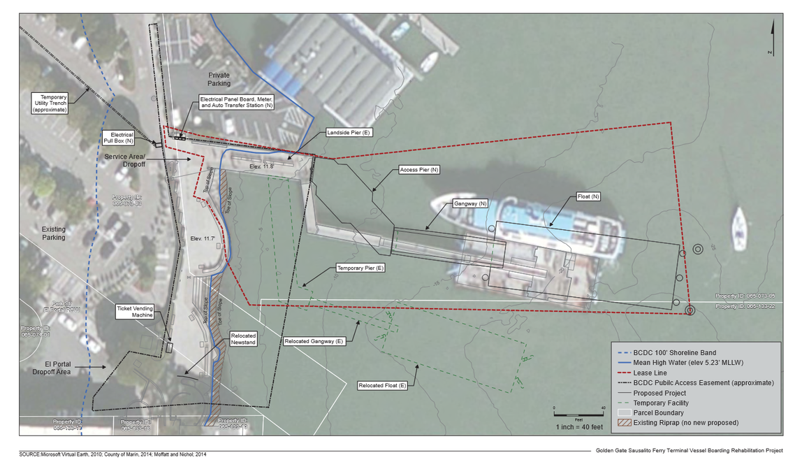
Construction's high carbon cost shouldn't stop smart growth

In the aftermath of Plan Bay Area's passage, development skeptics in Marin have circulated a study showing that new construction gives of much higher levels of CO2 than renovating existing buildings even if that new construction is done in a very ecologically-friendly way. This, they say, is evidence that encouraging new construction will only increase our carbon footprint, and so Plan Bay Area, not to mention smart growth itself, is a sham. While the study, from the National Trust for Historic Preservation, is accurate in its assessment, skeptics are on shaky ground with this line of reasoning.

The study tries to answer the question, "Is new environmentally friendly development as greenhouse-gas efficient as renovating old development?" The answer, as common sense and the study say, is an almost* unequivocal yes. Construction is remarkably energy-intensive, and on its own is not a good way to improve our environment. We need to retrofit our existing structures as much as possible, adapting our old, underused buildings for a more urban future.

However, in the small towns most opposed to Plan Bay Area, this won't happen. The Bay Area just is not a rust belt area that underwent the kind of decline whose aftermath this study tries to examine. Were we Baltimore or Cleveland, our conversation would be much different, as we'd have bountiful abandoned buildings to repurpose. This is happening now in downtown Detroit. But we're not Baltimore, Cleveland, or Detroit. Our most bountiful development resources are not derelict industrial park brownfields. They are our grey fields, the monumental wastes of space that are our office park and mall parking lots. That will necessarily mean new construction.

Development skeptics purport the two alternatives are Grow or Don't Grow, like their towns are islands, but that's not a good understanding of our region. Instead, the alternatives are Grow or Grow Elsewhere. Marin did wonders by protecting its greenbelt and is in many ways a precursor to Plan Bay Area and the urbanist movement. However, the result has been - as the veterans of those fights say - a chronic housing shortage, displaced growth into Sonoma and Contra Costa, and a steady loss of those counties' farmland and greenbelt. Nobody wants Marin to look like Walnut Creek (at least, I hope not), but Walnut Creek is in part a result of Marin's development policies, as are Rohnert Park and the Oakland Hills.

While we could give up and do the minimum in the name of reducing our CO2 footprint, in reality we would just push people further out from the City and cause more greenfield development. Just because the lost greenbelt is outside our county borders doesn't make the loss any less a tragedy. Even if that new construction were built to smart-growth standards, it would still be built, so the CO2 will be emitted no matter what we do.

It's a preposterous argument to make that we shouldn't build anything because it would add to our county's CO2 footprint. It's just tricky accounting, offloading the problem to other cities and counties.

A far better approach is to view these mandates as opportunities to make more small-town greatness. Our downtowns are the heart and soul of our towns, but between them is bland nothing. That we keep our density in safe downtown boxes but call it evil if it ever tries to escape is a profound disservice to our cities, region, and the environment development skeptics argue we should save.

Why is 34 unit-per-acre housing in downtown San Anselmo quaint but "stack & pack housing" just a mile east? Why is 40-unit-per-acre housing "San Jose-style massive apartment block" in Corte Madera when 89 110-unit-per-acre housing is a centerpiece of downtown San Rafael? Downtown Mill Valley could colonize its strip-mall-dominated flats, downtown Sausalito could grow into Marin City, downtown Novato could transform the North Redwood corridor a place worthy of Marin's second-largest city, and each move would make these great towns and cities even greater. This is the essence of smart growth

And the benefits of smart growth go beyond simply reducing CO2 emissions from travel. Smart growth positively affects public health, public safety, town budgets, water pollution, greenbelt preservation, farmland preservation, housing affordability, and beyond. Yes, repurposing emits less CO2 than new construction, but this is a horrible reason to halt all growth in small town Bay Area. Not only would the growth would just happen elsewhere, but we'd be throwing away a chance to make our towns even better and stronger. That would be a tragedy.

*The exception to this is renovating warehouses, which are so energy-inefficient it's best to just knock them down and start over.

A version of this post was cross-posted with Vibrant Bay Area.

Golden Gate Ferry promotes reverse travel to Larkspur

In an attempt to get more reverse travel from San Francisco to Larkspur Landing’s Marin Country Mart, Golden Gate Ferry is giving away tickets for some of its trips* for the month of August. Here’s hoping this will lead to more reverse-ferry trip promotions. It’s no secret that counter-commute ferry travel is, well, sparse. Survey show that some trips in the middle of the day have as few as 10 passengers for ferries equipped to carry 350. While this monumental waste of capacity won’t be solved entirely until Larkspur develops the Larkspur Ferry Terminal (LFT) parking lot, that doesn’t mean Larkspur Landing is only a desolate parking lot.

Marin Country Mart is the principal destination for the neighborhood. For a long time it was just another outdoor mall, but now the shopping center is trying to transform itself into a hipper destination, with jazz on Fridays and the Folkish Festival and food trucks on Sundays. The beer snobs among us have the always-wonderful Marin Brewing Company to visit, too.

People who want to participate print off an SF-Larkspur ticket (PDF click on the big image of a ticket on that page) at home, take one of the off-peak trips to Larkspur,* and get a return ticket from a Marin Country Mart retailer for an off-peak trip home.

All in all, it’s an ingenious way to get more reverse travel. It’s easy to think of Marin as Over There, out of reach for most people. By lowering the cost barrier, GGF could attract more regular riders and bring Larkspur Landing into the imagination of San Franciscans as a place they can actually go. There's no guarantee these new passengers will stay with the ferry after the promotion is over, but some may start to think of Larkspur Landing as someplace as close as another San Francisco neighborhood.

Other promotions should draw in employees of Larkspur Landing businesses, who may drive today but could take the ferry instead. This promotion would help workers that commute north in the morning, provided they get something at Marin Country Mart before heading south.

GGF's promotion, combined with the ferry shuttle, paid parking, and the new 7:30am departure, shows that GGF understands the challenges faced by its Larkspur ferry service and isn’t afraid to be creative in its solutions. I only wish its bus service was so bold.

*On weekdays, its any northbound departure between 8:30am and 3pm, and any southbound departure between 10:10am and 8:50pm. On weekends, it's the northbound 12:40pm and southbound 4:45pm.