In case you missed it, Marin Transit, in partnership with Golden Gate Transit, has made some changes to Marin’s bus system. The changes to existing routes saved enough money that they were able to add about 15,000 more service-hours to the system, meaning people around the county have better transit. The changes inspired a second look at my 101 corridor bus guide, and the result is here.
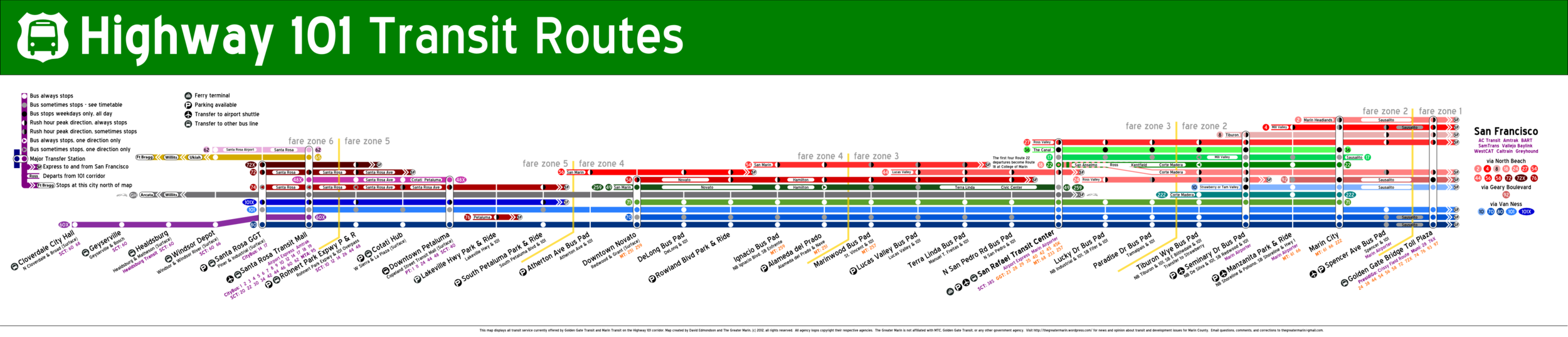
While the guide, technically called a “strip map,” reflects the changes to bus routes, I’ve also added non-GGT and Marin Transit routes to the map. Greyhound’s once-per-day north-south Arcata-SF service, Sonoma County Transit’s express services, and Mendocino Transit Authority’s service from Fort Bragg to Santa Rosa all made it onto the map.
It’s much less Marin-centric as a result, but no detail has been lost. Instead, Sonomans can know their options, Marinites can know their options, and all users get an expansive view of where they can go by transit in the North Bay’s 101 corridor.
This is the sort of map GGT needs to have at every bus pad and every transit center along its route. I created the original 101 bus map because I couldn’t visualize how all the lines interact and work together, nor could I tell what buses served which bus pad.
My home church, for example, is located off Smith Ranch Road, so it’s off the Lucas Valley bus pad. Since the 49 is the only bus whose schedule said it stopped at Lucas Valley, I’ll probably take it, turning what should have been a 15 minute ride into a 35 minute tour of Terra Linda.
With this map, I know I can have take the 70, 71, or 80. On a weekday evening, I might take the 44. But the 49? While it does serve the bus pad, it’s a local bus serving Terra Linda and the Civic Center, so it’s not the best idea.
A pocket version will be available in the next few weeks.