
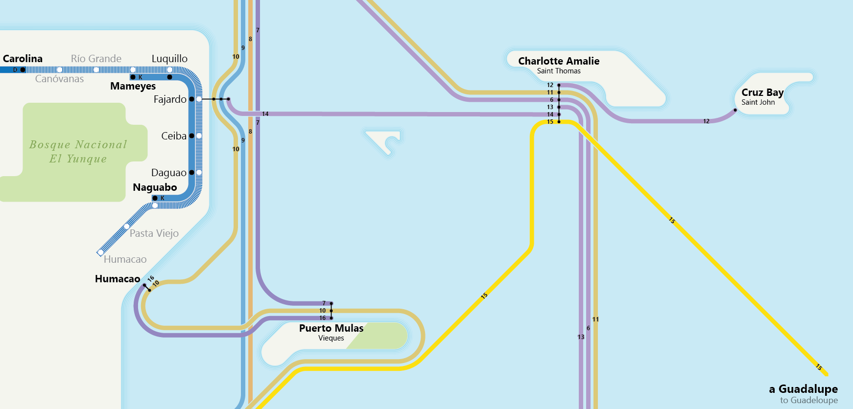
A new map is up in the store: Puerto Rico and the US Virgin Islands in the 1920s, on sale now for $25. All profits through the end of the year go to hurricane relief efforts in those areas.
This was an interesting map to make for a few reasons, not least of which was the language. It’s a Spanish-dominant, bilingual map of the area. As a mostly-monolingual English speaker this would have been hard enough, but using technical terms (branch line, flag stop, mainline, steamer ship, etc.) and a particular dialect (Puerto Rican Spanish) made it that much more difficult.
The most difficult part was, oddly enough, finding out whether Puerto Ricans call the Virgin Islands by their Spanish or English names. Spanish tends to use Spanish translations of place names (like Nueva York rather than New York). After reading through some Puerto Rican newspapers, I discovered that they use a hybrid, translating the territory’s name (Las Islas Vírgenes) but not the island or town names (Cruz Bay and Saint John, not Bahía de la Cruz and San Juan).
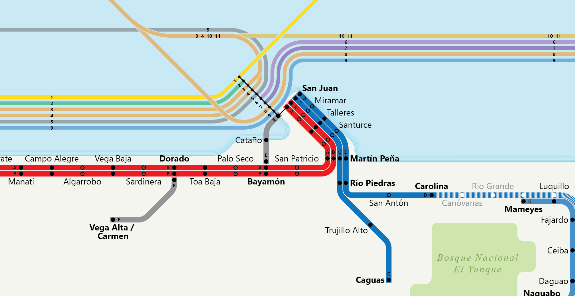
The other note is that this is the first map I’ve done using a multitude of sources rather than just one, drawing not just on The Official Guide of the Railways but also an operations manual from 1922 (where I learned that flag stop is una parada de señal, or signal stop) and a commercial traveler’s guide from 1924, which gave me the service patterns for most of the steamer lines. It had bus lines listed, but they had, at best, partial stop listings. Without a reliable contemporary road map, it would have been difficult to even show those. As a result, they were left off.
Back in the 1920s, travel in Puerto Rico (then called Porto Rico, apparently because of a typo that somehow made its way into US government documents and, from there, into business names; I fixed it for this map) was dominated by rail. Even though it took over 9 hours to go from San Juan to Ponce, a journey now made in just 90 minutes, the point was often to connect the small villages with one another, and to link mainlander-owned industries to the main ports of Mayagüez, Ponce, and San Juan.
Want to travel from New York to San Juan in the 1920s? Not a problem. Head down to Pier 11 or Pier 35 in Brooklyn on a Saturday with $50-$75 (now worth around $700 to $1,000). Expect to arrive in San Juan on Thursday ready to tackle the island. You could travel to Ponce by omnibus for a mere $4.50 ($65), tour car for $6.50 ($95) or first-class train for $0.03 per kilometer (so $8.28, or $120). Travel all over the island is fairly simple with tour cars, bus, and, of course, rail.
While it was possible to head to the Virgin Islands directly from New York, you would probably have done well to take a day in San Juan and sail from there. Fares from Manhattan’s Pier 47 started at $100 ($1,460), while taking a schooner from San Juan to Saint Thomas would be just $3 ($44). If you wanted to get to Saint Croix it would have been a bit of an adventure, as ships would anchor about a quarter-mile offshore, forcing travelers into dinghies for the journey to land.
Puerto Rico is a truly amazing place, with unique state and national forests (including El Yunque, one of the first nature preserves ever established in the Western Hemisphere), gorgeous beaches, a rich history and some absolutely stunning towns and cities. Puerto Rico has voted in favor of admittance as a full state; it deserves it.
The Virgin Islands is the only territory in the US that is majority black (the District of Columbia is, alas, now only a plurality black). It is home to some spectacular beaches and a fascinating history, including the earliest Western slave rebellion and a long history of Danish rule.
Pick up a copy for the Puerto Rican or Virgin Islander in your life – they’ll probably love having a little something of their history and home to hang on their wall.