The SMART Area, Part 2: All Those Cars

Over the next few days I’ll be posting my impressions and comments regarding the San Rafael SMART Station Area Plan. It’s such a large, complicated, and potentially game-changing document that it needs more than just a single post. Today we tackle parking. Subsequent posts will examine mobility, and the future of the area. So far, we've covered land use. With all these homes, all this retail, and all these commuters, parking could turn terrible without mitigation.  Although the transit options will be the richest of anywhere in Marin, the rest of Marin will likely remain just as transit-poor as it is today, so the Advisory Committee explored ways to deal with incoming traffic and where to put all the cars.

Overview

As you probably can guess, I’m not one in favor of parking.  You could call me a Shoupite, I suppose: parking has its place, but it should not be required, and where there is a shortage of parking it should be priced until there is no longer a shortage.  For regular drivers, this ensures they will always have a space roughly where they need it, mitigating the need for circling.  For commuters, it means the commuter lot won't fill up by some God-forsaken hour.  For cities, it means new revenue to plow into their neighborhoods and transit systems.

Excluding the 68 spaces that will be removed after SMART rolls into town, there are 144 metered on-street parking spaces (56 removed by SMART) in the Area Plan's study area that hit 50% occupancy at peak usage and 395 off-street, free all-day spaces (12 removed by SMART) that hit 90% occupancy by 11am.  This puts the total demand for off-street parking at for on-street parking at 100 and total demand for all-day parking at 389 spaces.  It's that second one that's awfully tight, and likely why there is overflow.

This poses a parking problem: how can the city accommodate new residences, retail, and offices while providing sufficient parking for new commuters and new shoppers without wrecking the transit-orientation of the area?  The Area Plan believes it can be done by adding more parking, including the area within the downtown shared parking district, and through demand mitigation.

More Parking!

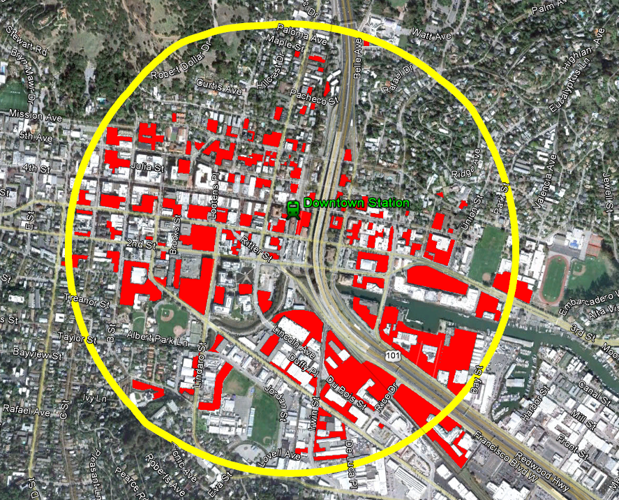
Click to enlarge. Red are parking lots & garages

I'm not entirely convinced there's a need for more parking given the huge number of lots - over 110 by my count - within a half-mile radius of the station.  Much of this is probably due to parking minimums imposed by zoning regulations, but there is still a plethora of parking.  I'd wager that around half the buildable space south of Mission is taken up by parking.  Look especially at the north side of Third Street!  It's just a long line of parking garages.  Little wonder nobody says, "Oo, let's check out that cool place on Third Street!"

As well, with over 90% occupancy of lots that are free, it would seems sensible to me to simply start charging for parking at the various commuter lots, and encourage owners of private parking to open it up to the public, or provide a mechanism for developers to purchase shared parking from those with a surplus, diminishing their own requirements.  As for spillover areas, setting up parking meters with a residential parking permit system should ensure commuters don't park in residential areas, while the city could allow  enterprising residents to rent out their driveways for the day.

Alas, the politics and mechanics of parking are a bit more complicated.  Everybody wants free parking right in front of their destination.  Downtown Tiburon, for example, is often accused of having no parking, but when the city actually looked they found scores of spots, just a little off the beaten path.  As well, with luck, San Rafael's surface parking supply will continue to decrease.  Pricing the parking supply implies that there are competitors to parking, such as transit, cycling and walking, but those are the topic of our next installment.  Decreasing supply implies the same.  The Area Plan takes non-car mobility seriously, but also suggests additional parking, as well as demand mitigation through car sharing.

More Parking, Less Demand

Car sharing is absent in Marin, mostly because our low-density cities and towns can’t support it, but studies have shown it dramatically reduces the need for parking. A single car share vehicle removes 14 cars from the road. The plan suggests allowing developers to forgo some parking if they support on-site car sharing. This is an excellent idea, as the more flexibility a developer has in its parking, the better the city will be. Still, I’d go one step further. As part of the car sharing rollout, San Rafael should give every household within walking distance of the redevelopment area free membership for a year, which would cost a pittance at around $184,000. Marinites are unfamiliar with car sharing, and this could serve to get people out of their cars and onto the sidewalks.

Even with demand minimized, this is still a transit-unfriendly county, and parking will be needed for residents, commuters, and customers.  To keep the burden off the developers, the Area Plan recommends including the area in the downtown shared parking zone, which allows retailers to count spaces in parking garages against their parking minimums, and building another parking garage along Third.

I would hate to see San Rafael add yet another garage onto Third, especially in the middle of an important walking area and so close to other parking garages and lots.  If a garage is really deemed necessary, a better location would be east of the freeway and extending the shared parking zone out to San Rafael High School and Unity Street.  Montecito Shopping Center is overflowing with cars, and they'd probably like having a bit more breathing room.  Besides, the newly tall buildings along Irving will want good access to a garage if they are to be built with less parking than normal.

I'd recommend extending the parking zone to residences as well.  With on-street parking at only 50%, some demand for off-street retail parking could be absorbed by the street, freeing up space in the garages and lots for residents to store their cars.

Parking will be seen as a problem anywhere one goes outside of the mall, but properly managing it will make the place actually attractive rather than just giant parking lots and garages.  Through demand mitigation (carsharing, transit, bicycling), innovative policies to broaden the parking supply, and parking pricing, San Rafael should be able to manage the influx of people to the area.  If parking will truly be a problem, a garage east of the freeway will open up that area for business and support the high-density development planned along Irwin.

Generally, a car is anathema to transit-oriented living, but there's little transit to orient around.  It is difficult to balance the needs of a transit-poor community with the needs of its transit system, but the problem of parking will remain a very real one for the area.  I hope the city will strike that balance - managing demand and providing mobility without encouraging car usage.
The SMART Area, Part 1: Land Use

Over the next few days I’ll be posting my impressions and comments regarding the San Rafael SMART Station Area Plan.  It’s such a large, complicated, and potentially game-changing document that it needs more than just a single post.  Today we tackle land use.  Subsequent posts will examine parking, mobility, and the future of the area.

San Rafael has released its draft downtown SMART Station Area Plan, and I must say that I’m excited.  So many good policies are wrapped into this – reducing parking requirements, form-based zoning, traffic calming, street engagement – that it has the potential to change the face of San Rafael and Marin by showing what can be accomplished with sensible zoning and real walkability.  While not a 180-degree turn in local planning practices, it’s pushing that direction.  If comments from the Planning Commission are any indication, there’s a hunger to go all the way, and that can only mean good things.

If you’re just joining us

San Rafael’s Station Area Plans cover the immediate areas around the upcoming Civic Center (for another post) and downtown SMART stations.  The downtown station will be located at the current site of Whistlestop Wheels and will be the terminus for the system’s Initial Operating Segment (IOS), which will extend north to Guerneville Road in Santa Rosa, roughly 37 miles away.

To prepare for the incoming train, San Rafael convened the Advisory Committee, consisting of representatives from San Rafael; the San Rafael Redevelopment Agency; SMART; the Golden Gate Bridge and Highway District (GGB), which operates GGT; Marin County; Marin Transit; and the Transportation Authority of Marin.  Their mission: to create the first real transit-oriented, mixed-use communities in Marin since the end of the Northwest Pacific Railroad in 1941.

This location is almost antithetical to transit-oriented development, located as it is next to the elevated section of Highway 101 that cuts San Rafael in half.  Second and Third are extremely busy arterials that function as extended freeway ramps, and the area is dominated by parking lots and auto-oriented uses, such as gas stations and body shops.

Almost antithetical, but not quite.  The station neighbors the Bettini Transit Center, which has buses departing frequently to all over the Bay Area and sees thousands of riders per day, and the Fourth Street commercial corridor.  Existing residential neighborhoods have a strong walking component, even under the freeway.  In other words, the neighborhood may be ugly but it is the transit and commercial nexus of the county, and that makes it ripe for redevelopment.

Better zoning

The key to development in this area is fairly basic: make it a place people want to walk around in and stay through safe sidewalks and streets, calm traffic, interesting sights and sounds, and high degrees of connectivity.  This is exactly what the plan advocates.

For land use, the plan recommends increasing height limits along Heatherton to 66 feet, enough for five-story structures, and to raise the limit to 56 feet along Irwin, as well as along Fourth Street to Grand.  Within these zones, the floor-area ratio would be raised to 2.0 and 1.5, respectively, while both areas would see density requirements lifted.  Residential uses would not count towards FAR, while parking minimums would be relaxed, although not eliminated.

I wrote last week about the need for residential development within the core, and the above would aid immensely in this endeavor.  Conceptual plans for the blocks immediately surrounding the station show the possibility of hundreds of new homes.  Given that a household can support 73 square feet of retail, just the example developments would support close to 20,000 square feet of retail.  Given the slack retail market in San Rafael, this will be a major boon to neighboring businesses.  With office development and the centrality of San Rafael to Marin, retail is likely to do extremely well.

The Montecito Neighborhood Association, which represents homeowners along Fifth Street between Irwin and Grand, complained that increasing height along Fourth on their block would overshadow their homes, and I’m inclined to agree.  Really aggressive land-use liberalization could accomplish the same goal of pulling the downtown core across the freeway without increasing heights at all.  Perhaps the city could lift lot coverage maximums, implement a setback maximum, and lift parking requirements while maintaining a two-story height limit.

I hope that the Montecito Neighborhood Association will not come out against larger portions of the plan than just those that would effect their own homes, and so far they have limited their strong opposition to just those recommended changes on the eastern side of the freeway. If they do begin to oppose developments in places that would not effect their homes, San Rafael could have a problem on their hands.

I’m concerned about crowding out the possibility of a second track through town, however.  If the system performs better than anyone expects, it could lead to major problems down the line and severely limit capacity.  I don’t want planning now to put a ceiling on the system if we don’t have to.

In any event, these land use patterns are new and innovative for Marin.  The Planning Commission was strongly in favor of the plan, and some even wished it would go further, instituting parking maximums or abolishing the minimum altogether, but they also felt that San Rafael was not ready for that sort of thing.  This sort of change comes slowly, and the Station Area Plan is the first step.

Housekeeping

First, let me say thank you to those that came out to the Happy Hour on Tuesday!  It was good to see you face-to-face.  There was some discussion about lane width and LOS in San Rafael, my pie-in-the-sky ideas about cycle tracks, and some consideration of how to focus development into downtown Santa Rosa.  Apologies if you missed the sign, but I'm glad at least some of you recognized my smiling face.  The (in)famous John Parnell was supposed to show, but, alas, had a family to attend to.  Next time, expect it at the Mayflower at 4th & D; no need to brave the punishing 29. Second, you should notice a few new links over on the right-hand side of the blog.  They are:

  • Pedestrian Observations: Written by mathematician Alon Levy, Pedestrian Observations is a heady, technical blog on transit and urban design that always produces solid work.  The commentariat is intelligent, well-informed, and just as interesting to read as Alon himself.
  • Human Transit: Written by transit consultant Jarrett Walker, Human Transit is his professional blog, dealing with the basic, underlying issues that form how we understand transit design and policy.
  • Planetizen: Not really a blog, Planetizen is a blog and a news links page, with articles on urban and transportation affairs from across the world.

Lastly, I'm back in DC.  I have a few irons in the fire that may or may not pan out for the blog, such as a new contributor and some small-time syndication beyond Patch.  If you want to contribute a tip, idea, or article, send me an email at thegreatermarin [at] gmail.com.

It was encouraging to see Marin doing its thing, and I can't wait to go back.  Until then, you'll always find me here.

Fatal Roads

It's not often we get to see in such a stark way how dangerous our roads are.  Luckily, ITO World, a UK transportation information firm, has done it for us, mapping every road fatality in the US from 2001-2009.

Zooming in to Marin, there are a few patterns.  I count 27 deaths along Highway 101 in the county, with the worst part being right at the border, and 2 deaths on 580.  On surface streets, I have:

  • 14 deaths in Novato, including a 9-year-old pedestrian girl on San Marin Drive in 2009
  • 10 deaths in San Rafael, including an 81-year-old pedestrian woman on 3rd Street in 2007
  • 3 deaths in San Anselmo
  • 1 death in Ross, a pedestrian
  • 1 death in Larkspur, a 53-year-old cyclist man near the ferry building in 2003
  • 1 death in Corte Madera
  • 2 deaths in Tiburon
  • 1 death in Sausalito
  • 2 deaths in Mill Valley, both motorcyclists
  • 25 deaths in West Marin

Over 9 years, 89 people have died on the roads of Marin.  Most were in vehicles or motorcycles, but there were two bicyclists and a number of pedestrians that were killed.  We're doing better than a lot of places, but it serves as a fresh reminder that roads are far more dangerous than we often remember.  What do you see in this map?

Transit Commuting Saves Marin Millions

Some have wondered why I made the previous post in isolation to the cost of a transit commute.  Although I did point out that a transit commute saves at least the San Francisco-bound Novato commuter a ridiculous amount of money, I did not examine the county-wide costs because I wanted to emphasize the benefits to living where you can walk or bike to work.  Transit, both in my post and Mr. Money Moustache's, is sloppy seconds: it still costs more than walking or biking. Another reason I left out transit is the lack of work-trip fare data.  Golden Gate Transit (GGT), the local bus and ferry agency, aggregates all fares for each mode into a single average fare.  In addition, GGT operates outside of Marin as a regional bus service in Sonoma and is just about the only way to get into Marin by transit.  Finally, the Blue and Gold Ferry, separate from GGT,  doesn't even share its data, so its fares are left out.  Each of these factors pollutes the data and makes any analysis less accurate.

But what the hell, right?  Let's call this a back-of-the-envelope calculation, the kind you make when proving a point at a party.  Don't take this as accurate, but take it as a rough idea of something approximating the actual amount Marin residents spend on transit and how much they could save by relying more on transit.

Golden Gate Transit's average fare for all riders on its ferries and buses was $3.02 in fiscal year 2010.  Taking this as our base, we find that the average transit commuter spends about $1,500 per year on commuting and $19,500 over a decade.  Good deal, a savings of $29,600 over the average car commuter per decade.

Transit makes up only 7% of work trips by Marin residents despite the cost savings.  Playing out our $3.02 average fare means commuters spend about $9.6 million per year on transit, or $124.8 million over a decade.  This is in comparison to the $7 billion we spend to commute alone.  If 1% of our car commuters switched to transit, that would be a savings of $6.8 million per year and $88.6 million per decade.  If our transit riders switched to single-passenger car commuting, they'd spend $88 million more per year and lose $1.1 billion in wealth over a decade.

Mind you, this is for the average commuter.  While a car commuter from Novato to San Francisco saves $11,000 per year by switching to transit, a car commuter going to Solano County probably won't find transit a feasible option at any price.  But if changing homes to be closer to work or changing jobs to be closer to home isn't an option, you should reexamine the long-term costs of that car commute and see how much taking the bus might save.  You might be surprised by what you find.

Value Capture and SMART

photo from Images_of_MoneyIf you follow the Marin IJ online, you've probably seen me posting a lot on SMART-themed articles.  Sometimes the comments from critics can be, to be kind, ill-informed, although it's typically a fun and spirited debate on the subject.  One comment that falls into the latter category recently got me thinking about value capture for SMART. I had just posted about Larkspur Landing's owners.  The SMART train was originally slated to extend down to the Larkspur Landing area and connect with a ferry into the City but has been scaled back to extend only as far as Central San Rafael as a cost-saving measure.  This, I argued, was a loss for the Larkspur Landing neighborhood and that the owner might want to pay to extend that last couple of miles:

Something I've been wondering about has been whether the owner of Larkspur Landing would be willing to help finance the Larkspur station. Although whoever does own that area isn't the most transit-oriented (to understate), being able to market your location as only 30 minutes to anywhere by bus, train, or ferry would significantly lift the value of that property.

Kevin Moore, who had seemed to be in opposition to the SMART project, replied:

In that line of thought... for every housing unit built near the new SMART stations, there should be a reasonable, but substantial "permit fee" for each bedroom and parking space. When Disney put in the monorail from his hotel to the theme park, he paid for it!

Although I was imagining a public-private partnership between SMART and Larkspur Landing, rather than a fee or tax levied across the whole system, Mr. Moore touched on an important concept.  When a station is built, it typically increases the value of the land around the station, boosting property tax receipts.  One method of value capture returns that extra boost to the transit agency, giving a consistent stream of income to the transit agency.

Mr. Moore's idea is another type of value capture, allowing the agency to assess a one-time fee on new residential development that occurs around the stations.  To tweak it a bit, the fee would be levied on whole units rather than bedrooms, to discourage strictly studio apartment developments, and would apply to retail square footage or some other commercial metric.  This would allow the SMART development to capture some of the value created by their system, hopefully bringing the system into a better financial position in the process.  A fee on parking would discourage parking spaces, which would be good for the County's traffic and for neighborhood walkability.  Ostensibly the developments would be exempt from parking minimums, allowing them to opt out of the spaces they felt they didn't need.

I'm hesitant to fully endorse the concept, however.  This provides a one-time stimulus to the system but doesn't have the staying power of a value-capture tax.  If SMART is really successful, it would eventually expand to a Phase 3, perhaps to Sausalito, Richmond, or even San Francisco itself, and slowly add a second track, and these expansions will need a stable funding mechanism.  Sales tax, as we now see, is not terribly stable, and is not terribly dependent upon whether the system works well or not.  As well, imposing a fee on any new development would disincentivize the new construction so desperately needed by the downtowns served by SMART.

The parking fee, though - that's a marvelous idea.  Any new space within a half-mile of a station could be levied at one rate, and any new space above the local parking minimum (at time of construction) would be levied at a higher rate, discouraging developers from overbuilding their parking capacities.  Although there shouldn't be a parking minimum in the first place, this would go some way to produce a less car-dependent corridor.

High Barriers for Low-Rise Affordable Housing

I've sometimes wondered why towns often lack mixed-use, low-rise development.  San Anselmo, in its draft housing element update (PDF, p. 47), found that adding a second story of housing on top of its downtown retail district would add 45 units.  Other cities in Marin could do the same.  Such plans would bolster tottering downtown economies, place low-income residents near transit and amenities, and help defuse some of the painful debates over affordable housing we've seen lately, all while maintaining the "village character" of our towns.  It should be a win-win, but the federal agencies charged with enforcing affordable housing policy are making it harder.  From Streetsblog:

[Department of Housing and Urban Development] lending standards dictate that the total value of mixed-use development projects can’t be more than 15 to 20 percent retail. Fannie [Mae] caps retail share at 20; Freddie [Mac] at 25 percent. And these standards set the tone for the private market — a tone that is consequently skewed toward single-family housing, and away from the pent-up demand for urban development with walkable amenities.

In other words, the loans that go to support affordable housing cannot go towards the kind of mixed-use development that would most help the poor and the cities they live in.  Second-story units in downtown San Anselmo would be ineligible for these loans under current law, rendering any plans for such units moot.

Congress for the New Urbanism is leading a campaign to change these rules.  San Anselmo and the Marin County Council of Mayors and Councilmembers should lend their full support and join CNU.