Report: the FRA makes trains less safe, more expensive

A new report out by the Competitive Enterprise Institute (and I suspect you’ll recognize half the byline), says the FRA’s safety regulations, enforced in the name of safety, perversely make us less safe. Rather than use the best practices of Europe or encourage train manufacturers to innovate, the FRA’s rules prescribe antiquated crash management technology from the 1910s. Dangerous and more expensive trains are the result. To find out why, you’ll need to read the report for yourself. It’s an easy read, just six pages, and it details how SMART, in the West, and Acela, in the East, have been dramatically affected by the FRA’s regulations, though they aren’t the only victims. You can see the stark difference between the two regimes in a crash test video that went into the FRA’s report on its own safety measures. The top train is FRA-compliant, while the bottom is compliant with European regulations from the International Union of Railways (UIC):

[youtube http://www.youtube.com/watch?v=NUpUJrk4QBE?rel=0]

The top train experiences something called an “override”, which you’ll find mentioned in the report. It’s what FRA-compliant trains too-often do in a crash. And, on the bottom train, you can even watch how, for a split second during the crash, the oncoming train pauses to absorb the crash energy. That's UIC crash safety in action.

Something I realized after the report had been written, too, was that the FRA's rules hurt domestic train manufacturers. FRA-compliant trains are illegal overseas, as they don’t meet UIC standards, just as European trains don’t meet American safety standards. This forces domestic manufacturers to choose between serving the tiny US market or the much larger global market.

Though bashing the FRA is a favored pastime among more technically-minded bloggers, desperately needed regulatory reform seems to have gained little traction where it matters most. Here’s hoping CEI’s white paper can change that.

Marin's towns are destinations

Population is a statistic everyone knows about a town. It's an important stat, as it tells us how many residents there are, roughly how many taxpayers there are, how many voters, etc. However, especially for large cities, it's extremely important to know how many people are in the city during the day. Commuters swell San Francisco's daytime population to over 950,000, a fifth more than actually live there. Daytime Population-County Chart

For smaller cities and towns, the daytime population numbers tell us how mobile people are and how much of a destination a place is. If there are a lot of workers coming in, it's an employment center. If there are a lot going out, it's a bedroom community. And if there are both a lot coming in and a lot going out, there is a mismatch between a city's jobs and its people.

The US Census Bureau ran the numbers on cities and places with a population of 2,500 or more, and the Atlantic Cities covered what the data means for big cities and regions. I'm curious about what it means for Marin.

Daytime Population-City Chart

Marin has been undergoing a transformation for the last 30 years, moving away from being a bedroom community for San Francisco and more toward being a jobs destination in its own right. Though the shift has been slow, Marin now has more jobs than workers, owing in part to a decline in the workforce and in part to an increase in jobs. The number of people commuting in has grown 3 percent; the number of people commuting out has shrunk 12 percent; and daily change in population has swung from -1.6 percent to +1.2 percent.

Data from other sources says most of Marin's 45,000 in-commuting workers live in Sonoma and Contra Costa, but we get some from San Francisco and Alameda as well. All told, these folks hold 37 percent of Marin's jobs.

There is a sense, however, that Marin is a collection of bedroom communities. While this isn't true in aggregate, every town and place in Marin sends a large portion of their workforce off to work elsewhere.

Daytime Population-Employment Ratios

Most interesting in this regard are towns like Corte Madera, which actually grow during the day but whose local workforce overwhelming leaves the city during the day. While the place itself is a destination, the voting constituency sees its town as principally an origin rather than a destination. When asked to choose which transportation investments to make, they will probably choose the ones that will facilitate their own commute out of town rather than the investments that will facilitate the commute to their town.

Also emerging from this data is San Rafael's place as Marin's downtown. Its population grows by almost a quarter, more than San Francisco, from 57,000 to over 70,000. Novato, with a similar number of residents, doesn't change at all during the day, sending out as many workers as it takes in.

So what?

These data imply that most Marin commutes are between towns rather than between counties, as every town in Marin has more of their workforce leaving than staying while the county has a whole has more of its workforce staying than leaving. This has implications for Marin's transportation and housing planners.

First, it means transportation infrastructure investments should principally focus on short-hop transportation: bike lanes, better intra-county transit, and walk-appeal improvements. Each of these will encourage short-haul commuters to bike, take transit, walk, or any mix of those. This would leave roads and parking lots open for those who really need or want to drive.

Second, it means transportation officials should examine how to facilitate long-haul transit commutes. Morning transit from San Francisco to Marin is pitifully bad. Hour-long bus headways make sure someone is always either late or early, while Larkspur Ferry drops commuters off in the middle of a parking lot with minimal transit service. From Contra Costa, 28-minute headways are better but the travel time is longer than it needs to be. Midday headways get as high as 60 minutes.

And third, it means the linkage between housing and jobs growth is best done on a county-wide, rather than city-wide, basis. Municipal boundaries are arbitrary, and it's clear Marinites ignore them when it comes to jobs and homes. A Marin County subregion for RHNA allocations would make far more sense than the city-by-city allocations ABAG is now forced to make.

This new dataset from the Census will be extremely useful to the big cities, but it can also open a window into the behavior of our little corner of the country. Marin is maturing into a proper inner-ring suburb, drawing commuters all its own. Planners and residents need to shift their thinking, and their projects, to match that reality.

UPDATE: If you want to examine the data yourself, you can find full tables on the Census website. I've also isolated the Bay Area county data and the Marin town, city, and place data into a single spreadsheet. There have been some significant shifts since 2000 at the place level, but considering  margins of error on the 2010 data I hesitate to read too much into them for the smaller places.

What's the deal with San Rafael's one-way streets?

One Way Downtown San Rafael must serve a dual purpose. On the one hand, it is the walkable urban core of Marin, a major center of retail, culture, religion, and office space. On the other hand, it is the gateway between Ross Valley and Highway 101, and it has turned two of its five east-west streets (Second and Third) into high-speed, one-way arterials for that purpose.

Though these streets are repellent to pedestrians and, therefore, retail, the one-way travel conversion allows speedy and efficient access to the freeway, so at least they function well as glorified on/off ramps.

So why are B, C, and D streets, which run north-south, one-way, too?

Stockton City Limits wrote about Stockton's one-ways and offered up Jeff Speck's rationale for converting back to two-ways:

One-ways harm downtown in several ways: First, as one-way streets are designed to get cars to their destination as fast as possible, increased automobile speeds create a more dangerous and uninviting environment for pedestrians. Second, one-way streets distribute traffic unevenly, negatively impacting surrounding commercial activity. Businesses along one-ways suffer from a lack of visibility as drivers can quickly speed by without even noticing that a business is there, or only drive by once a day, either on their way into work or on the way back home.

That last point - that businesses suffer - is especially true for businesses whose storefronts face away from oncoming traffic.

Now, Second and Third, unpleasant though they are, at least serve their (too-limited) purpose well. Traffic is heavy to and from Highway 101 along those routes. Folks who remember the one-way conversion some 40 years ago recall those roads as congested when they were two-way.

But the lettered streets are all pain with no gain. There's no improvement to traffic flow because there is almost no traffic flow to improve. In the meantime, all they do is hurt business, confuse visitors, and provide a raison d'être to the ugliest Do Not Enter sign in the city.

Notes from Choosing the Future We Want

A week and a bit ago, I had the privilege of speaking on a panel entitled Choosing the Future We Want, thanks to a kind invitation from Sustainable San Rafael. I got to see a couple of the regular commenters beforehand, bust out some market urbanism and Charles Marohn afterwards, and talk about Marin's history as a transit-oriented county on the panel itself. Honestly, it was a whole lot of fun. It's much more rewarding to talk with people who are skeptical of change than to comment at them online. I hope I sparked some interest in suburban urbanism and shed some light on where our county comes from. I hope I'll have a chance to post about some of this in the future.

Below is the video in full. You can download Linda Jackson's presentation here and mine here. You can also download the maps of the Interurban either in the Map Room or on the original post.

One point of clarification. The last commenter said that if the examples I gave were representative of the kind of affordable housing we'd get under Plan Bay Area she'd be all for it. Lucky for her, every one of the latter building examples are affordable housing. That's not to say affordable housing is all grand in Marin (I'm hoping to write a piece highlighting some of the worst examples I came across while preparing for my talk), but it's a representative sample. We need people like her fighting for good development, not fighting against all development because some will be bad. We can't rely on design review boards and planning commissions to promote good design if all they hear from the public is negativity.

Okay, enough of my soapbox here. Go watch the video. I start at 50:22.

[youtube http://www.youtube.com/watch?v=ChM4dJy5M3Y]

Bus load of route detours this weekend

Planning on using transit this weekend? You may want to take a look at Golden Gate Transit's Detours page, because there is a ludicrous amount of stuff happening around Marin for the next couple of days. In short, routes 10, 19, 22, 70, 80, 101 will be effected at some point on May 18 and 19. Most of this will have tight parking or be in places where your car will turn into an oven, so transit will be the best way to get around, as long as you know where to go. And it might be a good idea to make Route 19 (or perhaps the ferry) your designated driver after the Tiburon Wine Festival. Here's what's up:

SANTA ROSA ROSE FESTIVAL PARADE, SATURDAY, MAY 18, 2013 On Saturday, May 18, from about 6:30am to 1:30pm, GGT Routes 80 and 101 will operate on a detour in downtown Santa Rosa due to the annual Rose Festival Parde. During this time, the Santa Rosa Transit Mall will NOT be served. Customers are directed to temporary stops at Fourth Street & B Street.

TIBURON WINE FESTIVAL, SATURDAY, MAY 18, 2013 On Saturday, May 18, from about 7am to 6pm, Tiburon Blvd will be partially closed due to the 29th Annual Tiburon Wine Festival. During this time, GGT Route 19 will NOT serve the stop at Tiburon Blvd & Main Street. Customers are directed to the nearby stops at Tiburon Blvd & Beach Rd or Tiburon Blvd & Mar West St.

MARIN-SONOMA CONCOURS TOUR D'ELEGANCE, LARKSPUR, SATURDAY, MAY 18, 2013 On Saturday, May 18, from 6am to 11am, GGT Route 22 will operate on a detour due to the annual Marin-Sonoma Concours Tour d'Elegance. During this time, the southbound bus stop at Magnolia Ave & Ward St will NOT be served. Customers are directed to nearby stops at Magnolia Ave & Bon Air Rd or Magnolia Ave & Madrone Ave.

SALUTE TO AMERICAN GRAFFITI CELEBRATION, PETALUMA, SATURDAY, MAY 18, 2013 On Saturday, May 18, from about 5am to 10pm, GGT Routes 80 and 101 will operate on a detour around downtown Petaluma due to the annual Salute to American Graffit Celebration. During this time, the following southbound stops willNOT be served: E. Washington St & Gray CirFourth St & C StreetPetaluma Blvd South & F StreetPetaluma Blvd South & Mountain ViewPetaluma Blvd South & Crystal LanePetaluma Blvd South & US Hwy 101 On-ramp. Also, the following northbound stops will NOT be served: Petaluma Blvd South & US Hwy 101 On-rampPetaluma Blvd South & Crystal Ln,Petaluma Blvd South & Mountain View AvePetaluma Blvd South & G StreetFourth & C Streets, and E. Washington & Petaluma Blvd North. Customers are directed to the Copeland Street Transit Mall.

ASIAN HERITAGE STREET CELEBRATION, SAN FRANCISCO, SATURDAY, MAY 18, 2013 On Saturday, May 18, from about 5am to 9pm, GGT Routes 10, 70, 80 and 101 will operate on a detour in the SF Civic Center area. During this time, the following southbound bus stops will NOT be served: Golden Gate Ave & Polk StHyde St & McAllister St, and Hyde St & Grove St. Also, the following northbound stops will NOT be served: 7th Street & Market StreetMcAllister St & Hyde St, and McAllister St & Polk St. Customers are directed to nearby stops at Mission & 5th Streets or Van Ness Ave & Turk St.

AMGEN TOUR OF CALIFORNIA, SANTA ROSA, SUNDAY, MAY 19, 2013 On Sunday, May 19, from about 6:30am to 1:30pm, GGT Routes 80 and 101 will operate on a detour in downtown Santa Rosa due to the AMGEN Tour of California bike race. During this time, the Santa Rosa Transit Mall will NOT be served. Customers are directed to temporary stops at Mendocino Ave & College Ave.

BAY TO BREAKERS, SAN FRANCISCO, SATURDAY & SUNDAY, MAY 18 & 19, 2013 On Saturday and Sunday, May 18 and 19, GGT will operate on separate detours in downtown San Francisco due to the annual Bay to Breakers 12K race:

  • On Saturday, May 18, from 9pm until about 3am on Sunday, May 19, the northbound stop at the Temporary Transbay Terminal and ALL southbound stops on Howard Street will NOT be served.
  • On Sunday, May 19, from 3am until about 12pmALL southbound trips will END at Golden Gate Ave & Polk St andALL northbound trips will BEGIN at McAllister Ave & Polk St. GGT will operate a shuttle between the Civic Center (Golden Gate Ave & Polk St) and Mission & 2nd Streets. The southbound shuttle will drop passengers off at Muni bus stops along Market Street; the northbound shuttle will pick up passengers at stops along Mission St. Fares will NOTbe collected on the shuttle. NOTE: during this detour, GGT will NOT operate on Folsom, Fremont or Howard Streets.


Allow me to plan your Thursday night

Allow me to cut to the chase: Come see me speak about transit-oriented development on Thursday, May 9, at 7pm! At Dominican University!

Okay, so my subject, "Marin Traditions and Models for Transit-Oriented Communities," might not stir excitement in your heart, though it may if you're a regular reader at TGM. Still, you should come. You'll get to hear from experts from around Marin on what Plan Bay Area could mean for Marin, and how our county can approach that future without sacrificing our independence or character.

Still not interested? Then come for the Q&A panel discussion afterwards. We on the panel don't agree on everything, so you'll get a diversity of views on how Marin can approach the future in a positive way.

Still not interested? Then come to chat with me afterwards. I suspect that you may be able to sucker me into a post-panel beer.

Can't come? The whole thing will be on MarinTV, Channel 26, though at a later date.

Hope to see you Thursday!

choosingourfuturePBA2013v4-18-3

Tell the Bridge District No to Larkspur parking garages

Larkspur Landing at dawn The Golden Gate Bridge, Highway, and Transportation District (GGBHTD) could approve a parking garage at Larkspur Ferry Terminal in the next few months. Such a concession to a single mode would be bad news for transit-oriented development around Larkspur Landing and for ridership and would be a waste of money by the District.

Today I sent letters to all 19 members of GGBHTD's Board of Directors asking them to reject the garage in favor of other solutions, such as a Transit Center shuttle or a parking district. I also sent letters to General Manager Denis Mulligan and Deputy General Manager of the Ferry Division James Swindler, asking them to recommend against a garage.

If you want to do the same, sign this letter and let your GGBHTD Board members know. Feel free to use the letter below, either to email or snail-mail your response or as talking points for a phone call. You can find members' contact information on the Board website. Click on their portrait for more info.

Together, I'm confident we can defeat the money-wasting garages in favor of a solution that is more financially sustainable and better for our county and the region.

Dear Member of the Board,

I’m writing to you to express my concerns about the construction of parking garages at the Larkspur Ferry Terminal. In short, I feel this is an expensive solution to the problem of getting passengers to the ferry terminal. There are two less expensive ways to achieve the same ends:

Utilize unused parking stalls in Larkspur Landing.

  1. According to the parking survey conducted in the Larkspur Station Area Plan, there are 520 surplus parking stalls in the Larkspur Landing neighborhood. The survey found that these stalls will never be used by the buildings that own them.
  2. The larger garage under consideration by GGBHTD would add a net 569 new spaces, barely more than are available in Larkspur Landing at present.
  3. A shared parking arrangement would allow GGBHTD to use those 520 spaces.
  4. A shared parking arrangement would be beneficial to building owners, who would be able to charge the same parking fee as GGBHTD would on its parking lot.
  5. A shared parking arrangement would be beneficial to the owners of Marin Country Mart, whose parking lot is also at 100% capacity on weekends.

Implement a shuttle from the Transit Center to the Ferry Terminal.

  1. This replicates the promotional periods of the previous shuttle program, the only successful periods of that shuttle’s existence.
  2. Since this replicates the promotional periods, ridership estimates should reflect those of the promotional period. This is approximately 550 trips per day.
  3. Even if the shuttle has low ridership, the fare collected from each shuttle passenger remains $6 each way.
  4. Every passenger who takes the shuttle will open a parking spaces for a new passenger, which means another $2 parking fee and two $6 ferry fares.
  5. Therefore, each passenger on the shuttle will result in gross income of $26: two $6 fares from the shuttle passenger, two $6 fares from the driver who takes the shuttle passenger’s parking spot, and one $2 parking fee from the driver.
  6. If ridership reflects the promotional periods, GGBHTD would receive $785,000 in new revenue per year. Less the cost of a dedicated shuttle, this means GGBHTD would receive a $125,000 profit from the shuttle.

Option 1 is free except for staff time to make the arrangements with the City of Larkspur and neighbors. Option 2 is free to implement and would be profitable. In contrast, both the small and large garage will require subsidies to operate, on the order of $14,000 and $30,000 per year apiece, assuming the cost of replacement is included in budgeting plans.

I urge you to reject the garage proposals in favor of one or both of these alternatives. A chart of costs is included below. Detailed proposals can be found at:

http://theGreaterMarin.wordpress.org/tag/golden-gate-transit/

Thank you for your time.

Community Marin Plan is at odds with itself

Wrong Way Marin’s environmentalists recently released the 2013 version of Community Marin (PDF), an outline of priorities for how to conserve Marin County’s character and environment while still addressing the challenges of commuting and growth.

Though the plan makes bold recommendations for development and transportation – most prominently restrictions on greenfield development and a maximum house size – the plan’s recommendations are contradictory. It talks about infill development but demands onerous environmental and affordability requirements that make it even less likely to appear than now. And, while it talks about better transit, the plan maintains the status quo of car dominance: parking minimums, weighing transportation projects based on congestion relief, and HOV lanes on Highway 101.

Ultimately, the plan boils down to the old environmentalism that believes open space should be preserved, driving should be accommodated, tall buildings are bad for the environment, and housing markets are a myth. This has been the dominant strain of belief in Marin for at least 30 years, and Community Marin thinks that’s just fine.

The good

A fundamental environmental problem in Marin County today is the possibility of greenfield development, or development where there has never been development before. This kind of zoning is held out from Marin’s years of sprawl, especially the 1980s. That hundreds of homes could be built on Grady Ranch is indicative of this problem. Community Marin is right to call for a harder growth boundary to prevent this kind of sprawl from continuing.

In its place, Community Marin wants more infill housing, especially around downtown San Rafael but also around the Civic Center and Novato North stations.

The transportation chapter of the plan calls for all transportation projects to take climate change into account. Aggressive transportation demand management policies, like subsidized bus passes, car sharing, and Class I bicycle lanes (cycletracks), would tackle congestion.

The bad

Despite the call for more infill development, Community Marin goes out of its way to ensure any development will only be possible with considerable government largesse. Among the restrictions for housing development are 20 percent of most developed units be affordable housing; mandated use of green materials; examination of environmental impacts of development; no homes above 3,500 square feet; no development in the 100-year floodplain; full environmental review; full design review; parking minimums; and a hard 3-story height limit on most buildings. Though some of these restrictions could be mitigated by lifting restrictions on density or unit size, Community Marin is silent on these issues.

Commercial development, on top of those building and environmental restrictions, would need to pay a commercial impact fee, which compensates the county in full for the cost to build enough homes to house their employees. That means that for, say, every 600 square feet of retail space built, a commercial developer would need to provide enough money to the county to build a new affordable housing unit.

These restrictions are tantamount to a moratorium on for-profit development in Marin and would drive the cost of housing ever higher. Problems of affordable housing and senior housing would not be resolved. Even senior housing, if there were staff, would need to pay that commercial impact fee.

The only way to solve the problem of affordable housing is to allow the market to correct itself and to focus regulations on form rather than density. The recommendations from Community Marin for tighter zoning will push development into other counties even further from jobs. If Community Marin wants infill development, they need make it easier, not harder, for private entities to build.

The ugly

There aren’t new ideas in this plan to reshape how Marinites get around. Quite the opposite: biking, walking, and transit are seen as tools to address concerns of traffic congestion (as measured by the flawed level-of-service metric) and sufficient parking, not necessarily as transportation modes in themselves. Despite good suggestions – traffic calming, prioritizing Class I bicycle lanes – the overall push is to relieve congestion and improve safety, is often an excuse to remove pedestrians and bikes from ever-faster roads.

Take recommendation 8.14, which wants safer highway interchanges for all modes by improving traffic flow. That means higher speeds at interchanges, which means capacity improvements that will induce more driving, the least safe mode of transportation. Though the interchange will be safer, the population will be more exposed to crashes and death by automobile.

Most glaring are recommendations that encourage parking minimums, the steroids of automobility. Parking minimums externalize the cost of parking to the community at large, allowing the actual users of parking to get away with it for free or nearly for free. When combined with recommendations that level-of-service not be harmed by development, it’s a recipe for widened roads and intersections, which in turn makes them less safe or welcoming for pedestrians and bicyclists.

When it comes to transit, a necessary prerequisite to improved service is a moratorium on capacity improvements. Transit and cars are in competition with one another. Investments in roads and parking mean lower ridership on transit and more traffic on roads. Yet the plan seems ignorant of this well-understood law of transportation planning and calls for more road investment under the guise of “congestion relief”. A recommendation for a more extensive bus network rings hollow when another recommendation will suck ridership from the network that already exists.

If we want to decrease the mode share of cars and decrease how many miles we travel, we need to make a strategic investment in transit and bicycling alone, with roads restricted to maintenance funding.

There are other recommendations that betray a belief that Marin cannot be anything other than car-oriented. Recommendation 8.5 calls for more parking and more park & rides. Recommendation 8.11 supports the ludicrously expensive Novato Narrows project and a new interchange to service the Redwood Landfill, which will eventually close. Perhaps the framers of Community Marin don’t want to rock the boat too much, but it is bizarre to see environmentalists arguing for more cars. Given the strength of their lobby in Marin, they should throw their weight behind MCBC and urbanists to fight for fewer cars and less driving.

In all, Community Marin does well when discussing preservation concerns but falls flat when entering the realms of transportation and development. I suspect the framers of Community Marin share much in common with urbanists – the desire for strong towns and town character, a desire for affordable housing, a desire for open spaces and clean air – but they have gone about their recommendations in a way that does not reflect the proven best practices to achieve those ends. Indeed, their recommendations are often at odds with their stated ends.

Marin’s governments need to study these recommendations carefully before jumping onboard. If they’re serious about reducing CO2 emissions, about creating a more equitable housing market, about moving beyond the automobile, about investing in transit and bicycling and downtowns, this is not the blueprint to use.

Urbanism isn't Pruitt-Igoe

from Wikimedia by USGS It’s likely that Pruitt-Igoe, the public housing project in St. Louis, is the most famous and maligned image in architectural history. Its slab-like blocks rose from a scar in the urban fabric, the Corbusian ideal and an American dystopia. Yet at only 50 housing units per acre, this towering symbol of all things bad in urban design wasn’t all that dense. If we want to talk about density, we need to set Pruitt Igoe aside.

I mention Pruitt-Igoe because the image has emerged in Marin’s affordable housing debate. Bob Silvestri recently used it as an example of what he says the state and regional governments will force the Bay Area to build in a recent forum on affordable housing. Density mandates for 30 housing units per acre, he argued, would lead us to the worst kind of affordable housing and away from best practices.

Though there are plenty of reasons to oppose the regional housing needs assessment (RHNA) process, density and the specter of Pruitt-Igoe-like towers from Napa to San Jose is not one of them.

Rowhouses, when built right, come in around 50 units per acre, with older neighborhoods going a bit higher. Boston’s North End is over 50 units per acre. Washington, DC’s fabled Georgetown comes in at over 50 units per acre. In San Francisco, Russian Hill has 50, North Beach has 90, and the area west of Union Square goes as high as 536 units per acre. If density were the downfall of Pruitt Igoe, you’d think Union Square would be the center of a particularly wretched hive of humanity, not a trendy shopping district.

Urbanism means more places like this. Image from Google Maps

The causes of Pruitt-Igoe’s monumental failure could (and has) filled reports and books, but the failure can be boiled down to a deliberate denial of urban form. Stacking 50 units per acre atop one another while leaving empty grassy space around each tower for generic community gathering is a discredited idea that should have never earned such credence in the first place.

But to use this particular packaging of this particular density as an argument against density itself is disingenuous. It ignores common sense and the facts at hand. Good urban form can be low density and it can be high density, just as poor urban form can be either one.

And good urban form is based on the needs of the human as a creature. We walk, so a good city tries to maximize the pleasure of that activity. We are social, so a good city tries to maximize the incidence of casual socializing. That requires a certain level of compactness of buildings so that we can walk to the store and we can walk to the neighbor's home, but that look like Midtown Manhattan and it can look like downtown Mill Valley.

Let's have a debate about height and character that is really about how to build new development than enhances character, how to grow in that uniquely Marin way and make our county better. Let's leave behind the straw men and phantoms.

The Larkspur ferry crunch, part 4: The ferry's capacity

Larkspur Landing Larkspur Ferry Terminal (LFT) has an access problem: not enough people can get to the ferry. This shouldn’t be solved with parking garages, but rather with a shuttle and parking district in the short-term and transit-oriented development in the medium to long-term. But the terminal itself can only take so much ridership. In our fourth and final installment, we’ll examine the existing need, potential need, and the real and legal constraints on ferry service from LFT.

Need

At the moment, LFT is about 45 passengers over capacity on the morning rush hour departures. These benighted folks need to take an overflow shuttle bus into the city rather than the much more luxurious ferryboat. If GGT adds access for 500 more people to take the ferry, as seems to be desired, that would aggravate the overcrowding.

Adding capacity isn’t trivial. Though there are enough vessels to take people, there aren’t enough crew. Each vessel needs a captain and a crew, but these folks need to be paid for a full day, and there isn’t any need for a third full-time crew because of very low mid-day demand. While GGT is considering using one of their licensed office staff members as a captain for one morning departure as a cost-saving measure, there will be too much demand if ridership continues to increase and access is boosted as planned.

Rush hour, under the intense TOD scenario I outlined or from the SMART Station Area Plan, would probably bring about 350 extra riders, along with 120 or so from SMART and another 450 from parking expansion. If 70 percent of them use the ferry at the peak of the peak, that means another 600-650 ferry riders in the morning, or enough for one more peak hour ferry departure, which means yet another crew.

To make this make financial sense for GGT, the agency needs to figure out how to boost reverse-commute ridership and mid-day travel, which will mean more intense, or at least more interesting, development at Larkspur Landing. That, in turn, will probably require more trips. How far can GGT go?

Constraints

Corte Madera Channel. Image from NOAA. Click for much larger map.

Like all transit, ferry capacity is measured in how many vehicles of what size can be accommodated per hour. Physically, LFT is constrained by the size of the 2-mile long Corte Madera Channel, which provides an outlet for the ferries. It’s wide enough (about 265 feet) that two ferries can pass, but with a depth of only 9 feet it’s relatively shallow, so boats with even a moderate draft (how deep the boat’s hull goes under water) won’t be able to use it.

Logistically, LFT is constrained by its need for high-speed catamarans, which have a lower passenger capacity than slower monohull vessels. The largest catamarans in GGT’s fleet can fit 450 people, while its slower Spaulding monohull vessels can fit 715. Passenger demand for fast service to the Embarcadero wins out over capacity here.

Environmentally, LFT is further constrained by the need to protect the marshland around the Corte Madera Channel. Too many departures and the wakes will erode what is very rich habitat. To help combat this problem, GGT has limited the number of crossings between LFT and San Francisco to 42 per day. Each crossing, whether from or to San Francisco, uses one of those slots.

GGT is further constrained by the number of high-speed vessels in its fleet. With only 4 vessels, it can only run 3 departures per hour.

A theoretical maximum

But if we leave aside the environmental and fleet concerns and focus solely on the physical and logistical ones, we find that GGT could probably get 6 departures per hour from LFT. The highest-capacity catamarans that can sail the channel can hold about 500 passengers, so we can get 3,000 peak passengers per hour from LFT to San Francisco and vice versa. This is approximately 1.5 highway lanes worth of capacity in each direction. The Ferry Building should be able to handle that kind of intensity from LFT, but GGT may need to find or build a new berth in San Francisco.

To achieve this level of service, GGT would need eight vessels total – seven running and one in reserve.* The MV Del Norte, runt of the fleet, would need to be retired and the other catamarans would need to be retrofitted to fit 500 passengers. Five new vessels and three refurbishments should add out to about $56 million. Operating cost per hour of this maximum service is $12,420, so if GGT ran this for four hours per weekday, it would be about $13.2 million annually, less passenger fares, of course. Anything above this level of service would require a deeper channel, which would be more expensive to build and maintain.

The real maximum

As mentioned above, not only does GGT not have the fleet to run its maximum service but it’s limited to only 42 crossings per day. Using up 24 of those on rush-hour service isn’t going to cut it. Instead, we can reasonably assume a capacity of three departures per hour, or about 1,350 passengers per hour. It’s not fantastic, but that’s how much capacity the system is considering.

If GGT adds more service than this, and they very likely will need to, it will need to carefully manage its fleet, perhaps by running an asynchronous schedule. Two vessels would run between San Francisco and LFT all day, while three would only run during peak hours and remain in reserve in San Francisco during the day. This should allow it to stay within its needed 42 crossings without allowing headways to get too high or sacrificing late-night and early-morning service.

Alternatively, GGT could request more crossings from neighbors and the state. This would require a new environmental impact report that would identify mitigating measures to lessen the damage on the nearby wetlands. Under this route there’s a chance their request would be denied.

GGT must smooth its ridership profile through TOD. There is no other way for it to achieve continued ridership growth in a sustainable way. Ever-higher peak demand will be burden the system with high crew costs and wasted capacity. GGT can do this by shaping the development at Larkspur Landing and inviting SMART to build closer to the terminal (and therefore draw San Francisco commuters heading north). But GGT must also be careful not to overload its southbound capacity. Even at its theoretical maximum, GGT’s Larkspur ferry cannot move as many people as a rail line, and it cannot just pack the ferries ever-tighter as BART does.

A better Larkspur Landing will have new development, new parking capacity, a reinstated shuttle, and enough ferry capacity going in both directions. It will be a net positive to the transit agency’s bottom line and to its mission to take people off the bridge. It will boost the profile and financial situation of Larkspur and Marin County. New parking garages are the easiest but least effective way to boost access to LFT and improve the financial situation of GGT. It’s vital the agency look beyond those garages and to a better, stronger future.

*The total minimum round-trip is 70 minutes: 5 minutes loading/unloading at LFT, 30 minutes transit to SF, 5 minutes loading/unloading at SF, and 30 minutes transit back to LFT. Longer headways that don’t evenly divide into 70 would need to add time to the layovers.

The Larkspur Ferry crunch, part 3: Development

by flyron on Panoramio Larkspur has a parking problem. More accurately, it has an access problem, one that can be solved by harnessing extant parking and by running a shuttle service. These are ultimately stop-gap measures. If Golden Gate Transit is serious about turning its ferry service into the workhorse it could be, it needs to start thinking beyond the park and ride model to ferry-oriented development.

The financial case

Transit-oriented development could make GGT a mountain of money. Though as a public agency GGT isn’t necessarily supposed to make money, profits mean more stable finances and stronger service.

From a strictly real estate perspective, GGT could earn $2-4 million per year by leasing its parking lot to development, assuming fairly low-rise (four story) development to match the height of existing buildings around the neighborhood. If GGT wants to build on the land itself rather than lease to a developer, it could reap the full value of its land. If developed like the draft Larkspur Station Area Plan, that means roughly $7.8 million in gross revenue from residences and retail. If GGT adds 50,000 square feet of office space, it could quadruple its income to $33.8 million.*

Because GGT land isn’t taxable thanks to its status as a government agency, Larkspur should encourage any residential development on the terminal parking lot to have small units like efficiencies, studios, and one-bedrooms. Childless households attracted to small units are less of a burden on city services, so the lack of parcel and property taxes won’t be as great a problem. Sales taxes would still come in from these households, though, so Larkspur would get some boost from GGT land use changes.

If private property owners follow through on the SMART Station Area Plan, of course, the City of Larkspur would be able to reap the full benefits of more intense use.

The access case

What prompts this analysis, of course, is the current lack of access to the ferry, not simple financial concerns. GGT thinks Larkspur ferry ridership is limited by the ability of people to get to and from the terminal and wants to break through that barrier.

Transit-oriented development of the whole neighborhood of the sort called for in the draft Station Area Plan will provide a way to break through this barrier. More people will be able to walk to the ferry terminal, and that’s a good thing. The existing residents of Larkspur Landing seem to be heavy users of the ferry, with 0.6 weekday trips per person.** We don't know how many people may eventually live where the parking lot now stands, but there's every reason to believe they will be just as apt to use the ferry.

Residential TOD is a good way to build in riders who won’t be deterred by the lack of parking. With SMART or a bus shuttle, there’s a good chance GGT could attract car-free or car-light residents, which would boost other transit ridership.

Office TOD could be even more valuable and attract the reverse-commuter. There’s a glut of counter-commute capacity from San Francisco. Attracting San Franciscans to the ferry would allow it to make the most of its existing resources and are an easy way to boost farebox recovery.

Getting these reverse-commuters will require some skill on the part of developers. Only 2 percent of Marin’s jobs are held by transit-commuting San Franciscans. There aren’t many San Francisco commuters to begin with, and most of them are driving, not taking transit. A combination of marketing office space to San Francisco businesses, free transfers to Muni and BART, and discounted fares for employees of Larkspur Landing businesses could help boost the number of reverse commuters.

Any redevelopment plans need to be carefully evaluated. The Larkspur parking lot is on old marshland that will be very expensive to redevelop. GGT land isn’t taxable, so developments’ strain on city and county services needs to be weighed carefully. Neighbors and businesses need buy-in to improve the area. And traffic, surface transit, and parking are all thorny problems that need to be addressed (and are bigger issues than can be addressed here).

Then again, Larkspur Ferry Terminal may not have the capacity for more ridership. There’s already an overflow bus for morning commuters, and GGT is considering adding another morning ferry to cope with demand. In our fourth and final installment, we’ll examine the ferry terminal’s capacity constraints and what to do about them.

*Larkspur offices lease for about $43 per square foot, and apartments in Marin rent for about $2,000 per month. Retail rents for about $20 per square foot.

**At the moment, 25 percent of ferry riders walk to the ferry. It’s very likely that most of these riders live in the nearby homes north of Larkspur Landing Circle, as those are the only homes within walking distance.

Markets are the third way to affordable housing

Boston, with 53 units per acre of pure character and almost nothing over 4 stories. Image from Google Maps It’s no secret that the cost to buy or rent a home in the Bay Area is extremely high and rising. Thanks to a regional economic rebound and renewed interest in the kind of walkable living that defines San Francisco, demand for Bay Area housing is at a high.

Unfortunately, this means that only the most privileged can afford to purchase a home in our inner-ring suburbs. Blue collar workers, service workers, and young professionals making less than astronomical sums are having an increasingly difficult time finding homes they can buy or even apartments they can rent. And so a debate over how to accommodate affordable housing swirls around every planning meeting and town council election.

Advocates rally behind nonprofit housing and the state’s regional housing needs assessment (RHNA) process, which assigns each municipality and county a certain number of units they must accommodate. Others, especially in Marin, say cities and counties are managing their affairs just fine and resent anything that could be construed as meddling from Sacramento or ABAG.

Yet both perspectives neglect the economic underpinnings of our housing cost. Fundamentally, we have a shortage of housing for any income. Until either side begins to address this fact, we’ll continue to face deadlock and continuing cost escalation.

Market urbanism

Our housing shortage isn’t everywhere. Stockton and Vallejo can attest to that. Rather, the cost hikes have been in the walkable areas that have come into vogue over the past 10 years. Downtowns both large (San Francisco, San Jose, Oakland) and small (San Rafael, Napa) have seen their prices rise since the end of the recession.

While some of the demand in the big cities may come from name recognition, the principal reason for the price spike is that the supply of housing in walkable neighborhoods has not grown with demand for it. We have a classic housing shortage, and the only way out is to boost supply of walkable housing for all incomes, from luxury to low-income, by making it profitable to build such housing.

To some, this will sound like nonsense. We need affordable housing, not luxury housing. But the theory that increasing supply will stabilize prices has been borne out in at least one market.

Washington, DC, has seen a massive population boom. Since 2000, it has grown by nearly 10 percent, and now is adding 1,300 new residents every month. Though housing costs have increased (partly due to a lack of financing in 2007-2008 and partly due to a lag between demand for apartments and their completion), this year they are expected to be stable despite the continuing influx of people. Regionally, nearly 40,000 apartments are coming online in the next year, with another 30,000 the following year.

No government program could have forced such broad rent stabilization without direct price controls. Next year’s stable rents will only have come about because the region’s governments have worked with demand rather than against it. In the central city, DC is working on a revised zoning code that will promote high- and moderate-density walkable living. In the suburbs, counties are converting drivable retail centers into walkable mixed-use areas, sometimes far from the Metro rail system, relieving some of the demand in the central city.

The Bay Area could join DC and stabilize its housing market only by stepping back from the dysfunctional No Development vs. Affordable Housing debate. We must boost the supply of housing for all incomes or we’ll never get a handle on the problem.

Reform the laws, boost supply

Bay Area developers face a potent mix of restrictive zoning and anti-developer sentiment. We fear that any changes to our much-beloved downtowns will destroy their character, and that rapacious developers just won’t care.

Arguably, they didn’t care in the 1950s or 1960s. Ugly concrete replaced beautiful Victorian. Grassy hills became rolling tract homes. Governments helped by marking poor neighborhoods “obsolete” and tagging for them for demolition.

The laws put in place to stop this kind of idiocy worked, and developers now try to work within a city’s character rather than against it. Developers now face strict design review to ensure developments work with local character and architecture, or are built on characterless strip malls and dead zones.

Still, some of those laws hold back development to an undue degree. Take density limits, put in place to maintain neighborhood character. These ensure that only, say, 30 units per acre can be built in a given acre. While that seems like plenty of density, they encourage the largest units instead of the most rentable mix of units. A developer can’t charge as much for a studio apartment as he can for a two-bedroom, but since both count as a “unit” he’ll build a bunch of two-bedrooms. In Marin, this has meant continuing undersupply of studios and a rent hike of 14 percent since 2011.

Other constraints, such as parking minimums and inclusionary zoning, squeeze even more money from a project, rendering small infill developments unprofitable and impossible.

Cities should reform their zoning codes to make attractive and character-rich development profitable again. Density could be substituted with height limits, which would allow cities to keep a low-rise or mid-rise character while also adding housing units. Parking minimums, too, should be abolished in favor of alternative means of transportation and neighborhood parking plans.

Even in large cities, this will encourage dense development beyond BART stations. Though BART-oriented development is useful, there aren’t enough BART stations to make much of a dent in the housing supply. More importantly, these developments are often islands of walkability in a pedestrian-hostile sea if infill development is restricted to the BART station. Real cities are integrated fabrics, with buses, walking, and biking dominating short trips. Most of the walkable centers in the region follow this pattern and aren’t anywhere near rail transit. There’s no reason not to expand those town centers into the retail strips that dot the region or the vast office parks that dominate swathes of the East and South Bay.

Matthew Yglesias has written extensively about the need for infill development and upzoning. It is simply not tenable to prevent first-wave development from being redeveloped. Our land is simply too valuable to remain parking lots for offices and strip malls.

If the Bay Area is serious about affordable housing, its governments must tackle laws that keep supply from catching up with demand. We cannot rely upon nonprofits or government largesse to solve this economic problem effectively, nor can we freeze our cities and rents and call it a day. Only the market can fix the market.

The blog Sightline Daily has an 11-part series on legalizing real affordable housing, from zoning to density to rooming houses. It should be required reading for anyone involved in affordable housing policy.


The Larkspur ferry crunch, part 2: Bring back the shuttle

Larkspur Ferry Terminal It’s impossible to discuss the access crunch at Larkspur Ferry Terminal without the subject of shuttle buses. It seems like an easy solution to the seemingly intractable problem of how to get people to the ferry, but history shows it’s not so straightforward.

As mentioned Monday, the shuttle was a monumental failure with riders, principally thanks to free parking. Though ridership would spike to 10 percent of ferry patrons during promotional periods, it would drop back down after the promotion was over. It’s tough to compete with free and convenient.

Pay parking eliminates this concern. Thanks to a quirk in Clipper, riders will get a free transfer while drivers will not, replicating the situation during promotions. It is not unreasonable to assume that 10 percent of riders, the same number who used it during promotions, would use the shuttle. At that rate, the shuttle would actually make a profit, but not like a normal bus may.

Normally, fares paid directly for the bus service goes towards the route’s bottom line. Greyhound makes a profit on its buses, while GGT wants to recover no less than 20 percent of its operating costs with fares. A ferry shuttle, however, would be a loss leader. The real money isn’t in the fare paid for the shuttle ride; it’s in the much higher fare paid for the ferry ride.

Since demand for the ferry already outstrips the ability of people to get to it, every ferry rider who switches from car to shuttle frees a parking spot available for someone new. If 10 percent of ferry riders switch to the shuttle, another 275 people can drive to the ferry. Our drivers would take round-trips, so GGT would earn $12 per day in fares from them. And, since they’re driving, they’d pay out another $2 per day as a parking charge. Add it up and GGT gets nearly $3,000 per new passenger per year, a total of $785,000 in new revenue.

A simpler shuttle program

The shuttle program used in the past was a complicated and vast thing, with shuttle routes overlapping existing routes inefficiently while running long distances.

There's no need for that. While most ferry riders come from Central Marin, nearly all bus traffic runs through the San Rafael Transit Center. It's impractical for a shuttle to replicate all these routes, and why should it? If it wants to pick up more passengers up 101 or down Miracle Mile or out in the Canal, it has ceased to be a ferry shuttle and has become part of the wider bus system.

As well, running the shuttle outside of a very restricted 6-minute Transit Center-Ferry Terminal circuit opens the route up to delays from traffic or crash. Given the often long waits between ferry departures, a delay could force a long wait on riders. If ferries are held to wait for the bus, it would add delays for the rest of the commute hour.

Unfortunately, a dedicated shuttle would be rather expensive. At $660,000 per year, it would make a $125,000 annual profit, but there's a lot of waste. When ferry headways are long - up to 95 minutes - the shuttle wouldn't have anything to do. GGT could realize significant cost savings by extending an existing route to the ferry terminal instead.

By extending a short, frequent route, like Route 35, GGT would be able to operate a shuttle for only $340,000 per year. When ferry headways are long, the bus would be able to continue on its normal route and head to the ferry terminal for shuttle runs. When ferry headways are short, every run would hit the ferry terminal.

It’s important to point out that, since GGT will charge for parking no matter the outcome of its parking expansion, it must implement a shuttle to take up the slack of those who don’t want to pay the charge. If GGT rejects the shuttle but institutes the parking charge it will face a decline in ferry ridership rather than an expansion.

This kind of shuttle is not on the radar of GGT officials. They cite the old system's high cost, poor response, and ferry riders who said they want a shuttle for other people but not themselves. Though they want to time Route 29 to the ferries - a fantastic idea - they may miss an opportunity to add revenue to the system. Staff should draw up some shuttle options with projected ridership and combined ferry/bus revenue. The Board needs to see its options.

If reorganizing neighborhood parking is the “organization” side of ferry access, the parking charge is the “electronics” side of ferry access. The modest investment would add efficiency by segmenting the access market into those who really want or need to drive and those who would prefer to leave their car at home.

As we discussed Monday, there is no reason to invest in parking garages for Larkspur Ferry. Not only can GGT provide 520 more parking spaces for free but it can free up 275 parking spaces with a profitable shuttle service.

So we can accommodate plenty of Marin commuters, but GGT’s ferry faces other problems, namely severely underused afternoon and reverse-commute capacity. And if the aim is to boost ridership, there’s no more efficient way than increasing the number of people who walk. The next installment will tackle these issues with transit-oriented development.


The Larkspur ferry crunch, part 1: There's already enough parking

All the parking lots in Larkspur Landing. Image from Google Maps.

There’s no question that Larkspur Ferry has an access problem. If you drive, there’s a vanishingly small chance you’ll get a parking space after 8:30am. If you don’t drive, your options are to live in the neighborhood, walk for almost a mile along the freeway, bike for 15 minutes from the Transit Center, or take the miserably slow GGT Route 29 bus.

In response to this perceived lack of access, GGT is again investigating some exceedingly expensive parking garages paid for by a new parking fee. (They had last discussed a parking solution in 2007, when ridership was about what it is today.) While this would expand access, this solution fails to take into account the breadth of options available, including 520 unused parking spaces in Larkspur Landing that already exist.

Organization before electronics before concrete

An old adage marks best practice for facilities design: organization before electronics before concrete. The first, organization, rearranges existing resources to maximize their utilization. The second, electronics, upgrades the systems you already have so you can make even better use of your resources. The third, concrete, adds resources to your now-optimized pool. By prioritizing cheaper solutions before expensive ones, organizations can save a lot of money.

In the case of Larkspur Terminal, GGT’s supply of access to the ferry (the parking spaces, bus seats, bicycle racks, housing units, and office space in the vicinity) is the resource. As currently designed, there is a shortage of access, but GGT doesn’t need to add more garages just yet.

The Larkspur Station Area Plan revealed that, during the day, 520 parking spaces in the neighborhood went unoccupied. Though GGT does have a parking problem on its own property, the area’s parking supply is more than ample to meet the demand.

Graphic and data from City of Larkspur.

These spaces aren’t being used because the parking supply isn’t well-organized. People driving to the ferry have the option of parking for free on the street, for free in the ferry parking lot, or for $4 per day at the Marin Airporter. The other lots aren’t an option to them, as they’re reserved for more office workers than exist and patrons of Marin Country Mart who mostly come on the weekend.

Through a reorganization of the neighborhood’s parking supply, GGT could expand ferry parking by 520 spaces essentially for free.

GGT, Larkspur, and the businesses in Larkspur Landing would need to work together to figure out the precise rules, but the core of any plan would be pricing: a $2 charge per day for anyone parking in the area who doesn’t get parking validated by a retail store or who doesn’t have an employee parking pass. The owner of each lot would get income from their charge. Larkspur would earmark on-street parking charges to neighborhood improvements.

Coincidentally, 520 spaces is nearly the same number of spaces GGT wants to add in a large, 969-space garage. Since it would be built on 400 existing parking spaces, the garage would net 569 parking spaces. Unlike the essentially free 520, however, the 569 spaces would cost an astounding $44,000 apiece.

No need for concrete

Organization before electronics before concrete means other options should be explored before investing in costly new infrastructure. An examination of the neighborhood finds that parking already exists to meet demand, if GGT can harness it.

Of course, if the politics prove impossible and those open spaces can't be used for ferry riders, GGT will need to turn to the parking equivalent of electronics: a shuttle from the Transit Center. We'll tackle that question next.

The case of the missing sidewalk

No sidewalk. Click for Google Maps. Recently, I was driving down Second Street on my way to Pacifica and I noticed something I’d never noticed before: a block without a sidewalk, in downtown San Rafael.

Of course, this isn’t really new, simply unnoticed. It’s a blindness, really, to the needs of pedestrians on a street that has gone from a place to stroll down to a long onramp, but those needs are quite real.

On Second, between Hayes and Shaver, neither side of the block has a sidewalk. It’s a very built-up area, and there are sidewalks on the blocks before and after on Second. It’s a bit like paving the whole length of a road except for one isolated block that stays gravel.

It looks as though this block was an oversight. The transit line ran through here from San Anselmo, and buildings were built to turn away from that line. There wouldn’t be a sidewalk here anymore than there would be one along a BART line. Once the tracks were torn up and it became a road, sidewalks were installed on a lot of the right of way, but not this bit.

Not that people don’t use it. You can see a dirt track where people walk. The only other option is a detour onto First but, as any driver would know, not many people will take a five minute detour to get around a 15 second bit of gravel. If you have a stroller or are in a wheelchair, however, forget it. It’s not just that the dirt track is dirt, it’s also really narrow. There’s a power pole right in the middle of it, which cuts the space down to about a foot or so. Nobody except an able-bodied person would be able to get around it.

We wouldn’t accept this kind of treatment to drivers, so why is it acceptable to pedestrians? This is the most basic infrastructure for the most basic form of transportation available in a place where we want people to walk in the first place: downtown. Nader Mansourian, as an engineer and as director of Public Works at San Rafael, should have fixed this a long time ago. Maybe Mayor Phillips can get the ball rolling.

Larkspur's SMART station: Answering the critiques

Last time, we examined how the station got to be placed where it is. The gap in building the first and second segments gives activists a window to try to change the mind of SMART staff and board members, and by the looks of things they'll need the extra time. After seven years, the planned site of the Larkspur station is pretty well set in stone, at least if you ask the agency. Whenever asked to move it, SMART has taken the position that the location is final.

This, to put it mildly, is frustrating.

How can the concerns raised by Larkspur years ago and those raised by SMART be addressed?

Larkspur

When Larkspur first voiced opposition to a ferry terminal station, the city council was opposed to the project entirely and objected on three grounds: glare, aesthetics, and a desire to avoid renegotiating Marin Country Mart's planning documents.

The concern over glare is so odd it hardly deserves mention. Sun glints off parked cars in the ferry terminal and all over the neighborhood. Adding a train would not increase glare.

A train viaduct in Berlin. Image by Jarrett Walker.

Aesthetic concerns deserve more of a mention. Larkspur argued that views of the Bay would be blocked by an elevated structure and the neighborhood would be marred by a rail viaduct.

Though the vista is dominated by the ferry parking lot, viaducts are very rarely attractive things, at least in the United States. Since the train would run through the parking lot of a major shopping center and across the field of view of some of the stores, SMART should take a page from Germany and incorporate the shopping center into the viaduct itself.

A huge number of trains in Berlin run on elevated tracks, often running right through the city. Unlike the loud and grungy viaducts in Chicago or New York City, these have been integrated into the city by becoming buildings in themselves. Cafes, shops, and restaurants have taken up residence beneath the rails. In essence, the viaducts are very long buildings with trains running on the rooftop.

Marin Country Mart wants to emulate a maritime village, something vaguely European. By using the viaduct as buildings, Marin Country Mart could emulate something actually European. Though it would require cooperation from the SMART board, it would ameliorate the aesthetic concerns of the neighbors and add value to the shopping center's owners.

Marin Country Mart brings us to the third objection: planning. Larkspur officials in 2006 did not want to revise the Planned Unit Development plan that governs the shopping center, something that would need to happen if SMART extends a viaduct through their property, as two buildings would have to come down on the edge of the property.

But if both parties are willing to renegotiate, there's no reason why Larkspur couldn't amend the plan. Extending SMART through the shopping center makes a more direct connection between the train and shopping. That means value added to the center, especially if the viaduct can be made up as nice as the ones in Berlin.

SMART

Now that opposition in Larkspur has passed, SMART itself stands opposed to an in-terminal station. As far as I can tell, it's mostly intransigence. It's not in The Plan, so therefore shouldn't be added to The Plan. But publicly, SMART will likely say that it's an issue of cost (too high) and ridership (won't change much). These are things we can assess, though intransigence might go a bit deeper.

For cost, elevated rail structures like this one typically cost about $70 million per mile to build, including stations. SMART would need to build a viaduct 2,200 feet long, or about 0.4 miles. Multiply that against the average cost per mile and one arrives at $30 million. Let's add in $150,000 for building demolition, $100,000 for EIR amendments, and a generous $1 million for land acquisition, for a total cost of $31.3 million. That brings the cost of the whole system from $724 million to $755 million.

This is a bargain, especially for a project of regional significance. If SMART extends to the Larkspur terminal, it could transport a significant number of ferry riders. If it transports even a tenth of them (540 per weekday), the project will cost about $96,000 per trip, not counting the people who will occupy the now-freed spaces in the parking lot. The Greenbrae Interchange Project, in contrast, will add meaningful capacity for about 825 trips* in the peak hour at a cost of about $173,000 each.

Intransigence

SMART staff have dug in their heels on this project, but that's not to say they can't be persuaded or forced to come up with a good plan. However, will will take time.

The first thing you can do is understand the costs involved, as above. While the numbers in this post are estimates, SMART has not studied the issue in depth; they know just a hair more than I do about potential costs and ridership. Until there is a proper study, we cannot know for certain how much it will cost, nor how much benefit those monies will buy us.

The second thing you can do is start to lobby boards, commissions, and SMART staff. Since a ferry/train connection is a project of regional importance, TAM, SCTA, and MTC should rank it high on their list of congestion mitigation projects. $31.3 million is a pittance compared to what is doled out in a given year, and this is a critical link in the North Bay's transportation infrastructure. Residents of San Francisco and Sonoma have leverage as well, as the station will effect the usefulness of their own transportation systems.

Golden Gate Transit needs to push SMART to improve access, too. This will directly benefit GGT's ferry business and increase the value of their park and ride lot, should they ever decide to lease it to developers.

Find your SMART, SCTA, MTC, TAM, and GGBHTD representatives and tell them you want SMART in Larkspur.

*This is the number of new northbound cars that will be accommodated on the freeway. The project won't add any southbound or HOV capacity that will be used.

Marin: The original smart growth county

San Anselmo from Red Hill. Photo by the author. Last weekend I had the privilege to attend the annual New Partners for Smart Growth conference in Kansas City. Mayors, activists, councilmembers, and the odd blogger came out to share successes and failures in their communities in the hopes that others could learn from their examples. And after it all, one thing is clear: Marin has it pretty good.

Smart growth came about in the early 90s as the response to auto-oriented sprawl. Though it can mean many things, the basic purpose is improving access for walking and bicycling. Within a 15 minute drive is a certain number of residences and businesses. Within a 15 minute walk there is less. In a place with high access for walkers, however, there is too much density for everyone to move around in cars, leading to congestion if that demand isn’t well-managed. Similarly, in a place with high access for cars, there is too little density for people to be able to walk with any efficiency.

While there have always been low-density places for the people who want peace and quiet away from the town center, the last 60 years has seen a great proliferation of such places. In cities like Tulsa or Houston, the city centers themselves were transformed to improve automobile access at the expense of walking access. What activists term sprawl was the outward growth of this style.

In Marin, we rebelled in the 1960s after we saw what freeways were doing to the rest of the Bay Area. Though our beloved trains and ferries were long gone, destroyed by the Golden Gate Bridge and Highway 101, we refused to allow West Marin to be built over. We developed our landmark Corridors plan, ensuring sprawl would not rule our day.

A centerpiece of smart growth is a commercially strong and walkable town, and almost every city and community in Marin has one. These are spaces where you can walk from a nearby neighborhood or park your car once and stroll the strip. They are places with a high density of destinations. They define their community. After all, what would Mill Valley be without Miller Avenue? Or San Rafael without Fourth Street?  Other cities aren’t so lucky.

But a place where you can walk isn’t much good if you can’t walk anywhere else, or if it’s unsafe to bike around town. On this, too, Marin has a leg up on its peers.

Surprising though it is, the fact that we have sidewalks on nearly all but the most rural streets and arterial roads is a rarity, and it shows in the pedestrian fatality rates. Across the US, there are 1.38 pedestrian deaths per 100,000 people. In California, it’s 1.6 per 100,000, but in Marin it’s less than half that. In 2008, Marin only had 0.6 pedestrians die per 100,000 people. Though every death is a tragedy, Marin is doing far better than the country at large.

Our focus on smart growth – not to mention the transit-oriented bones left by that rail system – has paid off in how we commute. Our county has the second lowest rate of car commuters in the state, surpassed only by San Francisco. If we add carpools, we are tied with San Mateo County for third. One in three Marin commuters travel by a means other than a single-occupant vehicle. One in ten take transit, third best in the state.

That’s not to say Marin doesn’t have its shortcomings. Our bicycle infrastructure is good but not complete. Our zoning codes needlessly inhibit small units and drive up housing costs. And between those walkable town centers are drivable strips, meant more to be sped through than lingered in.

But Marin has a lot to teach the rest of the country. I was raised on the Marin sense of pride, the understanding that if only the United States would be more like Marin we’d have a more sustainable, prosperous world. Marinites should smile that the movement towards smart growth around the world is in essence an attempt to take the path Marin took 40 years ago. We should smile, that is, and roll up our sleeves.

Larkspur has a second chance to do SMART right

Elevated Ferry Station While Sonoma gets to reap the benefits of SMART, including a $15 million expansion of the IOS to the Santa Rosa Airport, Marin’s commuting public rightly grouses that it doesn’t serve their needs. Yet by ignoring Larkspur Landing for now, SMART has a chance to do what it should have done from the start and plan for a station in the ferry terminal.

A core principal of transit planning is connectivity. Any network is only as good as the strength of its connections, and transit is not excluded. The strongest sort of transit connection is the cross-platform connection, which allows you to hop off your train or bus, cross the platform to your transfer and be on your way. It's like switching planes in an airport by walking one gate over.

In contrast, a weak transit connection forces riders to leave one station, walk a couple of blocks, and enter another station. Rather than boarding a connecting flight at the gate next to yours, we need to hike across the airport to another terminal entirely. Though this may be tolerable once in a while, as a daily commute it can crush even the hardiest transit enthusiast.

Sadly, SMART has opted against convenience and in favor of soul-crushing. Current plans call for locating the ferry station a half mile from the ferry terminal, requiring transferring riders to either walk along parking lots and unfriendly streets or wait around for a shuttle. A commute that might already involve 2 transfers will become one involving 3.

Larkspur residents, most of whom who won't even get direct SMART access, rightly complain that this makes little sense. The Station Area Plan for the Larkspur Landing neighborhood calls for relocating the station into the terminal and decries the poor site chosen by the SMART board.

SMART's draft environmental impact report contained a draft plan (very large PDF) to put the station in the ferry terminal. Back when station sites were being planned, staff created four alternate proposals for Larkspur, including two with better access to the ferry. The best one placed the station adjacent to the current terminal entrance at the end of a half-mile of elevated track. Given the current going rate for elevated rail, this option would cost about $30 million plus land acquisition costs. That’s about one-fifth the cost of the Greenbrae Interchange Project next door.

Yet at the request of the Larkspur City Council (PDF), SMART went for the station plan staff explicitly recommended against. The city complained that the removal of two buildings would require modifying the plan that governs Marin Country Mart, and that an elevated rail line would obstruct views of the Bay. They also were concerned about cost, though Larkspur wouldn't need to pay for the extension. Another concern raised earlier by staff is that a station in the ferry terminal would make extensions to Corte Madera or San Quentin more difficult.

Though these concerns are well-intentioned and should be addressed in any plan to relocate the station, it's foolish to scuttle a dramatic service improvement over parking lots and fantasy expansions that are decades from reality.

And here is where we have a new opportunity. By splitting construction of the line in two, SMART has given Larkspur residents a chance to change that seven-year-old bad decision. Nobody likes to run across an airport to catch a plane, and no commuter likes to walk across a half-mile of parking lots and traffic to make a transfer. Larkspur needs reverse its earlier request and demand a world-class transit connection, and residents should ask for the same. And SMART should listen.

Next time, I'll examine the city council's original concerns and how they might be addressed.

New bike share plan suitably cautious

Capital Bike Share (Ballston) Last Thursday, TAM released a cautiously optimistic report (PDF) on implementing bike sharing in Marin. The preliminary report’s caution is well-warranted, as the county’s infrastructure and urban form are far different from bike share pioneers Paris and Washington, DC. If Marin can thread the needle and create a quality bike share program, it could be a pioneer for other suburbs.

Introduction to bike share

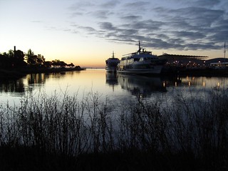
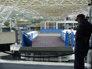
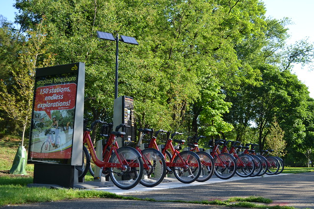
Bike share, the system examined by TAM, is a bicycle rental/transit hybrid. Bikes are stored in stations, like the one pictured at right, which are scattered through the area. Users purchase a membership for a certain amount of time, usually just a day, week, month, or year. While a member, users can pick up a bike from any station and drop it off at any other station. If done within a certain time, like 30 minutes, the trip is free. If the trip goes over that time limit, a fee is levied for every subsequent half-hour.

The point isn’t to check out a bike for a round-trip but rather for each short leg of a short journey. Want to get from downtown MillValley to Whole Foods? Check out a bike, ride it to Whole Foods, dock it there and do your shopping. After you’re done, check out another bike from the station and ride it back downtown or wherever you want to go next.

I’ve been a member of the Washington, DC, system for most of the time it’s been active. Capital Bikeshare, or CaBi, is used by tourists to get between museums on the National Mall, commuters to get to work, revelers to get around after the Metro system closes, and for general trips around town. I’ve used it for all those purposes and it works great for all of them.

The key is to have bicycles and docks always available at a given station, and to have stations conveniently located. There’s nothing worse than arriving at a station to find the bikes are all gone or to find there’s nowhere to dock your bike, especially if there’s nowhere nearby that does have a bike or dock.

The company contracted to operate the system will “rebalance” the bikes from one station to the other. In DC, the operator pays a fee if any station is empty or full for more than two hours. Users know where bikes, docks, and stations are by looking at screens on the stations or with a smartphone app.

The Marin system

Bike share phases 1, 2, and 3

TAM wants a bike share system to serve primarily the commuting public, to solve what transit planners call the Last Mile Problem. When a rider hops off a bus, they’re at a location that might a ways away from their final destination. To get to the final destination, riders typically walk, though bikes are a common sight on Marin’s bus fleet. With bike share, a rider doesn’t need to bring their own bike.

With that in mind, the first stations would be focused on moving people from downtowns to ferry terminals and transit centers. Twelve stations, one in most of the downtowns and one at the two ferry terminals, would provide a way to get commuters around the county. Subsequent phases would make more stations around activity centers, which would make the system more like CaBi.

Total cost would be around $720,000 for the first phase and $2.2 million for full build-out.

Obstacles

A major barrier to the success of the bike share system will be the paucity of quality bike facilities between downtowns and activity centers. Though it is possible to ride through most of Marin, it isn’t always pleasant, and the safest route is sometimes far out of the way.

Between most downtown pairs lies a few miles of bike-hostile arterial roads. Though most have safer parallel routes, those parallel routes don’t access the businesses that grew up along the arterial. Since bike share is a utility rather than leisure system, the separation of businesses and bike routes diminishes just how much utility bikers can get from the system. Given how low density Marin’s origins and destinations already are, the last thing we need is to diminish separate bikes from businesses.

Marin’s demographics are another potential obstacle. The foundation of most bike share systems is the 25-34 age group. Though they’ve been growing in Marin, the group is a fraction of the size it is in DC or San Francisco. Planners want to harness the 35-45 age group instead, though they’ve been reticent about adopting bike share elsewhere.

Opportunities

The bike share report seems to underestimate the power of tourists in Marin. Particularly in Sausalito, a major driver of use will be tourists. DC’s system was never designed for tourists, but once the system opened on the National Mall the bikes became ubiquitous. Sausalito already gets thousands of tourists. If Marin’s system is integrated with San Francisco’s quite delayed plan, I suspect a huge number of tourists and day trippers will use bike share to hang out around Sausalito and Tiburon. As well, commuters to the City will be able to use their bike share membership at home and for their commute, taking away some of the demand for bike space on ferries and buses.

Bike share is its own best advertiser. Once a small system is up and running, demand springs up elsewhere. People, even transit-savvy New Yorkers, often don’t understand what bike share does before it’s active, but once it is people know it and love it. Richmond, Novato, and maybe even the closer-in West Marin villages like Bolinas and Stinson will want in on the action.

As a nifty indirect effect, bike share puts people in touch with the infrastructure in their communities. A street looks different from a bike. What feels like a narrow lane behind a windshield can feel like a broad avenue on a bike, and what feels slow in a car feels fast to a biker. Advocacy for better bicycling facilities can come from a well-used bike share system.

Oddities

The report isn't without its problems. The draft plan doesn’t adjust the projected level of usage over time which, frankly, doesn’t make sense. People will use the system more as more stations become available and as people get used to the idea of bike share. It looks like they copied the final station proximity numbers into Phase 1 and Phase 2 but kept the introductory usage numbers for each phase. It would be good to get that sorted out.

The first phase includes only one station in Novato, a small loner in the middle of downtown more than an hour from the next nearest station. Though it is census area with the most bike commuters in the county (6.1 percent!), it doesn't make sense to add only one station. Riders who arrive and find the station full will be stranded in the middle of nowhere with the clock ticking on their bike.  Stations in Tiburon and Mill Valley are similarly isolated.

There are missed opportunities for new stations in San Anselmo and Mill Valley. In San Anselmo, the commercial centers along Center, namely Yolanda Station and Lansdale Station, should be quality sites for infill. Miller Avenue at La Goma and Tam High should score higher as places for expansion.

It is a true shame that College of Marin doesn't get a station until Phase 2. Young people form the core of any bike share program. Leaving out a major destination for them until later in the program is foolish in the extreme. One of the more isolated stations - Novato or Tiburon - should be placed there instead.

National context

Bike share is sweeping the nation. It is transforming cities across the country and will soon reach the Bay Area. Marin should not get swept up in the trends for their own sake, and I’m glad the county is proceeding with caution. The next phase of planning is another baby step – $25,000 to find sponsors and study the potential subscriber base, which will put more flesh on the report’s bones.

If Marin’s system does pan out, it will mean bike share is far more flexible than the high-density systems that launched the wave. That means suburbs like Marin, from Surrey, BC, to Staten Island, NY, will have an example of a functional system to hold up as an example. The good news for Marin, then, would mean good news for the country.

San Rafael tries to draw workers away from solo commuting

A new commuter program from the City of San Rafael aims to draw municipal workers away from driving alone to work. Though it needs work to encourage active commute options, namely bicycling and walking, it will do wonders to promote transit and vanpool commutes. The pilot program, designed by city officials with help from city analyst Rebecca Woodbury, puts a monetary incentive behind commuting by vanpool, carpool, and transit:

Vanpools and carpools:

  • After two months of carpooling, participants will receive a one-time stipend of $50 and be eligible for quarterly raffles.
  • Those who lease a van for a vanpool get $600 in help on top of TAM's $3,600 vanpool subsidy. After six months participation, vanpoolers get a one-time stipend of $200.
  • Prime parking spaces for carpools and vanpools.

Transit:

  • Public transit riders get a $20 “try it” transit voucher. A free Clipper card with $20 pre-loaded or a one month SCT pass might be a better way to encourage use.

Both:

  • Use up to $240 per month in your pre-tax paycheck dollars for vanpool and public transit. It's unclear if the $75 state transit benefit is included in the package.
  • For each trip made using an alternative mode of transportation, get a raffle entry. This includes bicycling and walking.

Drivers also get a $100 subsidy towards the purchase of an electric vehicle. You can read more about all the programs on San Rafael's website.

At first glance, there's a fair amount of emphasis on encouraging these modes without a lot of emphasis on subsidizing them after the fact. This makes some sense, as people tend to stick with the transportation mode they're used to rather than switch to another one. After six months of vanpooling, I suspect the routine will be established well enough that it just won't occur to people to switch.

The focus on start-up costs could be applied to biking as well. I'll bet a number of employees live within biking distance, but their bikes sit gathering dust and rust in the garage. There are also safety issues, like bicycle lights, that might not be available to the casual daylight biker. The city could offer to pay for the cost of a bike tune-up and lights or sponsor bike clinics at City Hall and Courthouse Square. Though not part of the formal program as it should be, this kind of bicycle benefit might end up as part of Bike to Work Day events, so bikes won't be entirely sidelined.

Walkers are harder to subsidize, as shoes don't typically wear out so quickly. However, a one-time financial reward or a $50  gift card to a local shoe shop could be enough to get some people out on the sidewalks.

Given how intransigent San Rafael can be when it comes to biking and walking issues, especially through downtown, getting staff on their feet and in bicycle seats could subtly shift the overall stance of the city.

Woodbury told me that they have a limited budget for this pilot program, and money could shift if people don't embrace a particular mode. Biking, she said, might end up as one of the beneficiaries if the interest is there.

So far, unfortunately, interest in general has been fairly slow. Two weeks in, Woodbury is the only one to use the transit benefit, for example. She told me the group who devised the plan will be meeting soon to discuss marketing and outreach, so it may be a few months before things start to really roll.

Programs like this one helps move people towards the diversity of transportation options available to them. It benefits the health of employees, boosts transit ridership, and helps the environment all at once. Here's hoping the city as employer will lead the city as government to do a better job promoting its position as the relatively transit-rich center of the county that it is.